Best Road Trip in America: The Land of Est!
This is the land of est … the highest, the lowest, the largest, the saddest, the oldest, the greatest, the longest and perhaps other “-ests” you may discover for yourself along the way. Here’s why we believe the stretch of US Highway 395 between Lone Pine and Bishop might just be the best road trip in America.
Where is the Land of -Est on US Highway 395
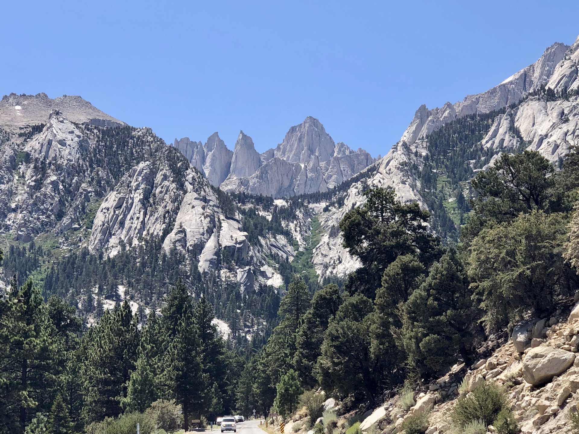
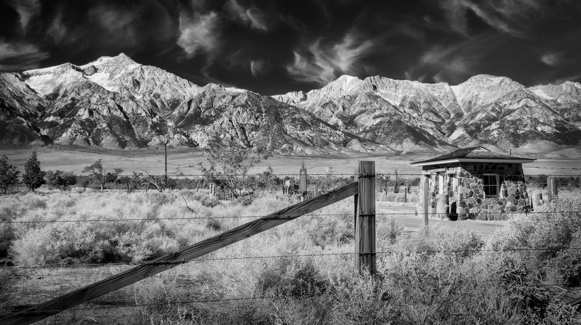
US Highway 395 runs for 767-miles from San Diego to the Oregon state line, with all but 87 miles of it in California. It begins in Hesperia and runs through the Mojave Desert (the driest of all North American deserts). Then it enters into the Owens Valley, which, at 4,500 feet above sea level (ASL) is flanked by the Sierra Nevada to the west and the White and Inyo Mountains to the east. Peaks on both sides rise above 14,000 feet ASL making this one of the deepest valleys in the United States.
Just beyond Bishop the road begins to climb alongside the Sierra Nevada with its highest point at 8,138 feet in altitude at Conway Summit in Mono County. The road passes four summits on its journey northward then at Topaz Lake it dips into Nevada for 87 miles. After one final summit pass, Simee Dimeh Summit, the road exits the mountains and follows the receding escarpment of the Sierra and into the urban areas of Carson City, Reno and Sparks.
Returning to California US Highway 395 runs through Sierra, Lassen and Modoc Counties, serving the towns of Susanville, Ravendale, Termo, Madeline and Likely. At New Pine Creek, CA alongside the eastern shore of Goose Lake it enters Oregon and continues north to the Canadian border.
The “Land of -Est” is here in the Owens Valley between Lone Pine and Bishop. In just 60 miles along this splendid route you will find a world of adventure and fascination. You may find your …est!
As you travel along US Highway 395, be sure to stop at these 20 iconic spots for great photo opportunities.
Start: Eastern Sierra Interagency Visitor Center (mile 0)
The gateway to the Highest and the Lowest

Situated just south of Lone Pine at the junction of US Highway 395 and CA State Route 136, this beautiful facility is operated by federal, state and local governmental agencies. This includes the US Forest Service, Bureau of Land Management, National Park Service, Los Angeles Department of Water and Power, Inyo County, Mono County, California Department of Transportation, and California Department of Fish and Wildlife.
Take in the Highest Mountain in the Lower 48
Here there’s a wonderful view of the highest summit in the contiguous United States – Mt Whitney, rising to 14,505 feet ASL. It is also the gateway to the lowest point in the United States, Badwater Basin in Death Valley. These two points are just 84.6 miles apart in distance, yet worlds apart in climate, ecology and character.
The summit of Mt. Whitney sits well above the tree line and very few plants grow near this all but barren summit. Its only animal visitors are transient species like the phoebus apollo butterfly and grey-crowned rosy finch. Hikers are a more numerous visitor in the summer months and the climb to the top of this mountain requires a permit and diligent planning.
Mt. Whitney is the most frequently climbed mountain peak in the Sierra Nevada, and perhaps in the US. The staff at the visitor center can help you plan for a future adventure to hike to the top of Mt. Whitney should you wish to add this to your list of achievements.
Facts About Death Valley
Badwater Basin is 282 feet below sea level and is accessible from the visitor center by road via Panamint Valley and into Death Valley. Winter is a wonderful time to visit the basin when temperatures are warm and pleasant. For ideas on what’s there to see and do read our article From Stones That Roll Mysteriously To Scotty’s Castle. Summer temperatures regularly reach or exceed the 120 deg F mark and Death Valley holds the record for the highest reliably recorded temperature in the world of 134 deg F – a record set in 1913.
This vast salt flat and small spring-fed pool at Badwater Basin also appears barren, yet it is home to some animal and plant life, including the pickleweed, small aquatic insects and the Badwater snail.
The Visitor Center Experience
Sierra Forever (formerly the Eastern Sierra Interpretive Association, ESIA) operates the Discovery Bookstore at the Eastern Sierra Interagency Visitor Center where literature and information about Mt. Whitney and Badwater Basin, plus many other wonderful attractions in this area can be found.
In addition to the natural wonders of this area an impressive display about the Los Angeles Aqueduct is a major feature of the visitor center. The aqueduct has been a controversial and contentious project since its inception and is impressive in its size and scope. The history is chronicled in reports, photographs and artifacts – the largest of which is a section of the pipe – all testaments to the ingenuity and perspicacity of humans.
The Eastern Sierra Interagency Visitor Center is open daily with limited service from 8:00am to 4:30pm.
Stop 1: Museum of Western Film History & The Alabama Hills (mile 1.7)
The largest natural “Hollywood Back Lot”
Spend a couple of hours at the Museum of Western Film History. Then, take a self-guided tour of Movie Road in the Alabama Hills (brochures are available at the museum) to get an up-close look at the actual filming locations of many famous movies.
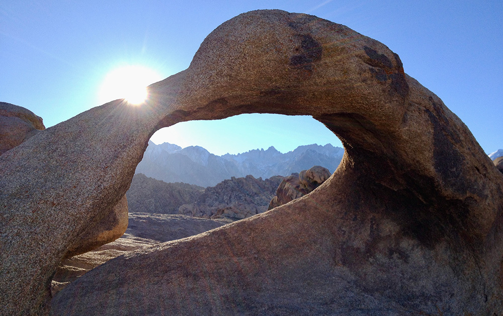
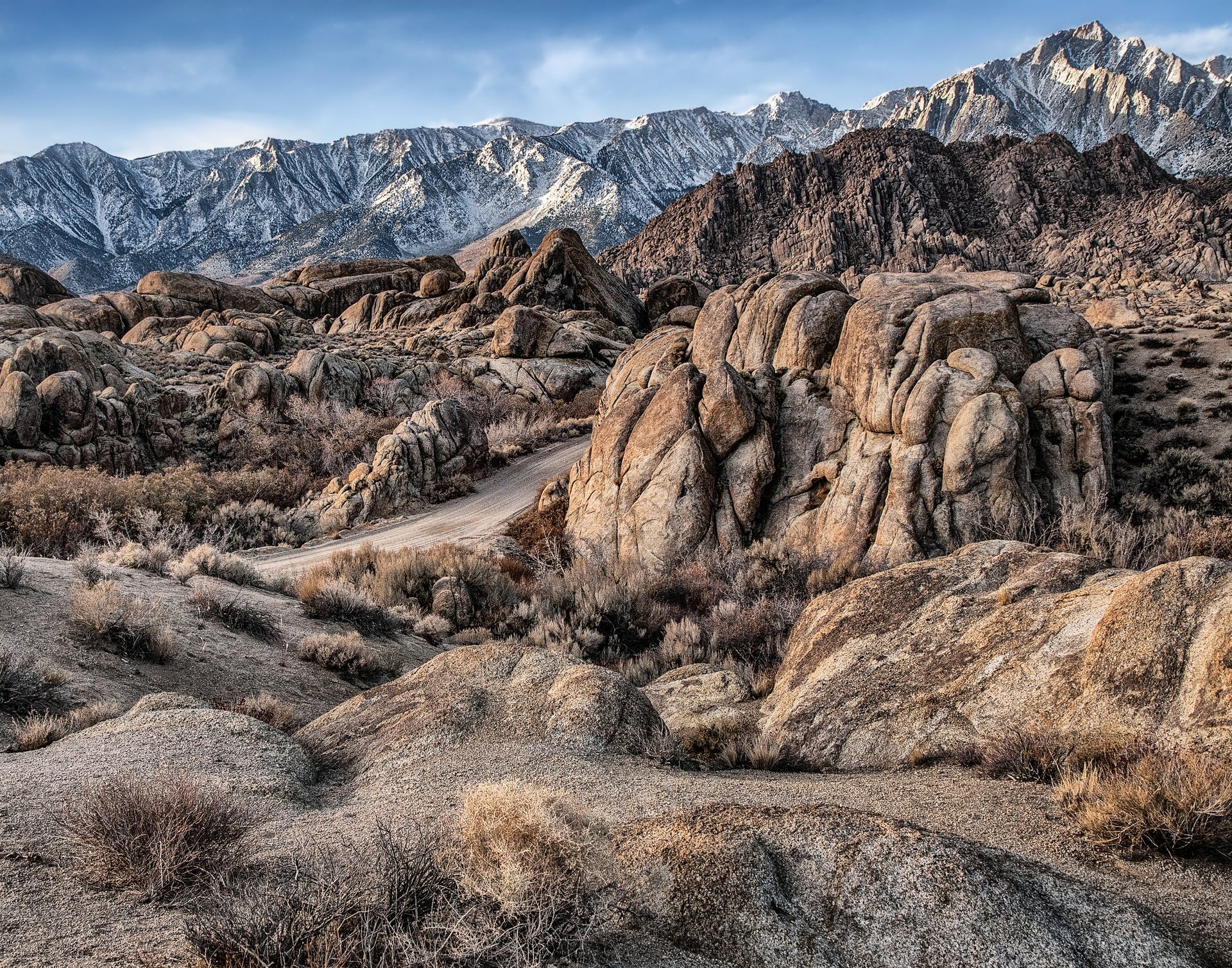
The Alabama Hills, nestled in the foothills of the Sierra Nevada just west of Lone Pine, is one of Hollywood’s favorite filming locations. This monumental landscape provides a myriad of settings for movie backgrounds and evocative scenes. The beautiful rock formations of the hills bordered by a vast open plain rising majestically to the snow capped mountains beyond has been a prime location since the early 1900s.
One Landscape, a Thousand Stories
This backdrop has been used to portray many different settings around the world. These include the valleys of the Himalayas (in Gunga Din, 1939), the Arabian Desert (in Iron Man, 2008), and the ever-evocative American Wild West (in Bad Day at Black Rock, 1954). It was this essence of the Wild West that originally drew producers here. Hundreds of western feature films and TV shows were set in this diverse and expansive landscape.
The first documented production filmed here was Round Up, almost 100 years ago. The area continues to be a sought-after location for feature films, TV shows, and commercials. The museum houses an extensive collection of original costumes, vehicles, props, posters, and other memorabilia. It is a wonderful representation of the industry, its producers, directors, actors, crews, and entourage who visited here and created the films that will entertain for generations to come.
Stop 2: Manzanar National Historic Site (mile 11.7)
The preservation and interpretation of the legacy of one of the saddest periods in our nation’s history

One Camp, Ten Thousand Lives; One Camp, Ten Thousand Stories
During World War II the US government ordered the internment of almost 120,000 Japanese American citizens and resident Japanese aliens. Men, women and children were forced to leave their homes and detained in remote, military style camps.
Here, at what was then called the Manzanar War Relocation Center, which was one of ten such camps in the US, over 10,000 people spent all or part of WWII.
What You’ll Find Today
This 814-acre site, once part of a 6,200-acre tract, includes remaining structures and the Manzanar Visitor Center. The center has 8,000 square feet of exhibits, a bookstore, and a theater showing the award-winning documentary Remembering Manzanar.
The display covers over a century of history, focusing on the internment camp. Exhibits include a large-scale model made by former internees, historic photographs, audiovisual programs, and artifacts. A key feature is a graphic listing the names of over 10,000 Japanese Americans held at the detention facility.
Journey to Manzanar
A commemorative event is held every year in April. Many surviving former internees, along with a growing number of young people, travel to Manzanar to remember and pay tribute to those who were detained here.
The site, under the auspices of the National Park Service, Manzanar National Historic Site is open every day from dawn to dusk to vehicle traffic and the visitor center is open daily.
Stop 3: Eastern California Museum (mile 18)
Home to probably the largest collection of historic photographs from the area
Located in Independence, this museum was founded in 1928 and has been operated by Inyo County since 1968. Its mission is to collect, preserve, and interpret objects related to the cultural and natural history of Inyo County and the Eastern Sierra.
The museum holds about 27,000 photographs dating from the late 1800s to the 1950s. It also has a large collection of artifacts and an archive of history and family files. These files include newspaper clippings, original documents, and other materials about the towns, people, and events that shaped the region.
Showcasing the Heritage of the Eastern Sierra
Managing this collection requires a computerized database with 15,500 records. Each year, museum staff handle around 200 requests for information or photo reprints. The entire collection is held in public trust and serves as an excellent resource for researchers.
Permanent exhibits showcase life in the Eastern Sierra. Topics include transportation, Native American communities, the LA Aqueduct, Norman Clyde, and more. Special and rotating exhibits are created from the museum’s vast photo and artifact archives.
The Eastern California Museum is open 6-days a week, Thursday to Tuesday from 10am – 5pm, closed on Wednesdays and all major public holidays. Admission is free and donations are greatly appreciated.
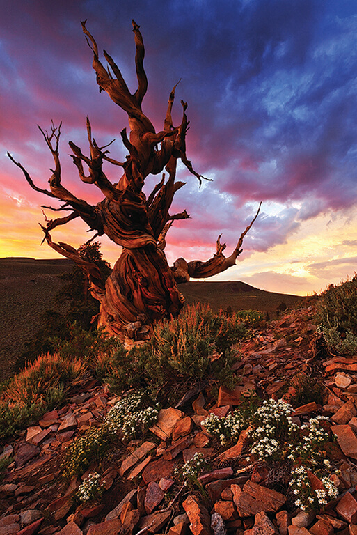
Stop 4: The Ancient Bristlecone Pine Forest (mile 44.7 to Highway 168 east junction)
The Oldest Trees in the World (23.2 miles to the Schulman Grove Visitor Center)
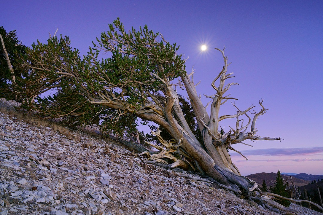
High above Bishop in the White Mountains are the world’s oldest living non-clonal organisms, the Great Basin Bristlecone Pine (Pinus longaeva). Growing between 9,800 and 11,000 feet ASL in an all but inhospitable climate these trees live for thousands of years.
The Schulman Grove and Schulman Grove Visitor Center is open annually from mid-May through November, weather permitting, and this is where you can see these ancient trees.
From the visitor center at 9,846 feet ASL the Methuselah grove trail makes a 4.5-mile loop. Here in the Methuselah Grove, unmarked to protect its identity, lives Methuselah which is 4,847 years old. Just two years ago an older tree, unnamed and also unmarked, was determined to be 5,065 years old. It sprang to life in the year 3051BC and for over 5,000 years it has lived on this cold, rocky mountaintop that has remained largely unchanged.
There are spectacular vistas looking out eastward over Nevada’s basin-and-range region and side trails connect to interesting, old mining sites.
Visit the world’s oldest living things, the trees that have seen the greatest passage of time on earth.
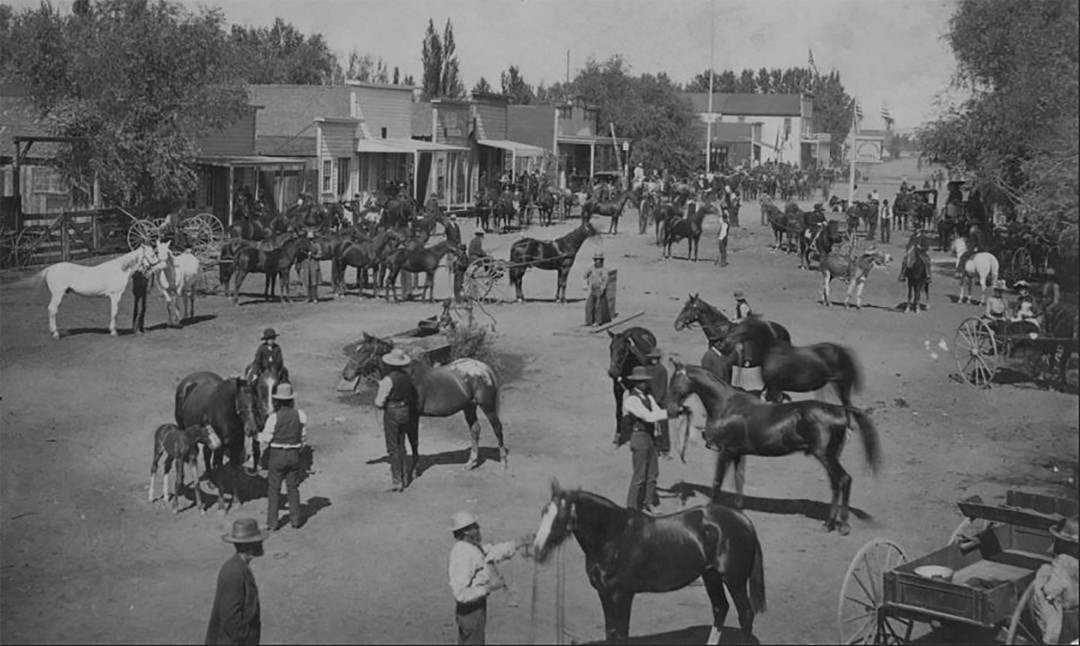
Finish: Mule Days & Mule Days Parade (mile 60)
The greatest fun you’ll ever have with mules and the longest non-motorized parade in the US

Every Memorial Day weekend, over 30,000 fans from around the world gather in Bishop for a world-class equestrian event. This tradition began in 1969 as a send-off for local packers and outfitters starting the summer season.
Today, over 700 mules, trainers, riders, and packers participate in 14 mule shows. These include Western, English, youth, barrel racing, gymkhana, packing, shoeing, chariot racing, team roping, and driving. The event also features a country music concert and lively country dancing.
Among the many highlights of the weekend is a parade along Main Street that is believed to be the country’s longest non-motorized parade. All parade floats and entries must be animal and/or human powered and, naturally, mules are the predominant mode of transport. If you’re planning on going here are 5 Things to Know About Bishop’s Mule Days to make the most out of the event. If you’re bringing the kiddos be sure to read our Guide to Mule Days – FOR KIDS!
Mule Days a Wild West test of skills presented and participated in by real working cowboys (girls are cowboys too) in a truly authentic western town. Our local mule motto says, “Anything a good horse can do, a good mule can do better.”
Bishop Information Center – 218 South Main Street
Stop in at the Bishop Information Center where the knowledgeable and friendly staff can show you where to go and what to do to and give you information on more great activities and adventures in Bishop.
When is this road trip best?
This is a wonderful road trip any time of year. However, some parts of the tour are better enjoyed during certain seasons. For example, Death Valley is ideal during the cooler months from late fall to early spring. The Bristlecone Pines, on the other hand, are only accessible by vehicle in the summer. Of course Mule Days is always held the week of the Memorial Day weekend. If you plan to visit during the winter, we’ve created this Eastern Sierra Tour Winter Guide to help you navigate the area.
Perhaps you might spend a few days making this journey. Or maybe you visit the Eastern Sierra often and can devote a day to each of these discoveries. Whenever and however you choose to take this 60-mile journey of discovery it might just be your sweetest, greatest, funnest, happiest adventure.
Find your est … on highway 395!
Cover Photo by Nolan Nitschke
Written by:
Gigi de Jong
Gigi is “crazy mad in love with Bishop.” Since moving here in 2006 she has made it her mission to participate in as many of the outdoor activities as possible. She learned to snowboard, improved upon her very average climbing skills, took long hikes, has driven up and down innumerable mountain roads and 4x4 tracks, cycled and occasionally tumbled down mountain bike trails, taken to the roads on a bicycle or motorcycle – sometimes for fun and sometimes to commute, and successfully completed her first attempt at a triathlon. She spent 10 months touring the western US and Canada on a bicycle and after 4,000 plus miles returned to Bishop – for the beauty of the place and the spirit of the community. “My soul belongs here,” she says.