Mountain Biking in the Eastern Sierra
Do you love mountain biking? We bet you do. That’s why you’re on this page. Welcome!
We think that there are few other places on earth that offer as much opportunity for year-round mountain biking than the Eastern Sierra. This is one of the most topographically diverse and beautiful regions in our country. We have an abundance of dirt trails and tracks that seem almost endless. And access to mountain biking rides range from super easy and leisurely, to highly technical and challenging — and everything in between.

Fatbiking Buttermilk Country
Did you know that Inyo County (the second largest county by area in California) and its northern neighbor, Mono County, are two of the least populated counties in California? Together these two counties cover a little under 10% of the total land area of all of California, with a staggering 99% of land in Inyo County and 93.6% of Mono County designated as public lands.
What makes that even more amazing is the geography of the region. Inyo County is home to the lowest and highest points in the contiguous United States. The lowest point, Badwater Basin in Death Valley National Park, sits at 282 feet below sea level and a mere 85 miles west (as the crow flies) is the highest point, Mt. Whitney, at 14,505 feet above sea level. That means our topography is incredibly diverse, and that creates huge opportunity for fantastic mountain biking.
Within our lowlands, midlands, and highlands are hot, dry deserts; warm, wet riparian river areas; cool, grassy meadows; shady, green high alpine forests; steep-sided, rocky canyons; snow covered valleys and craggy mountain peaks. It’s a pleasure seekers paradise.
Local residents are notably proud and pleased that we have so much space for a huge variety of cycling throughout the year. Our guests tell us that they visit often because each season offers something different and exciting to explore each time. And we know that many pro riders train in our big backyard so that they can get the benefit of high-altitude acclimatization, a variety of freely accessible trails, and friendly hospitality in our welcoming western town.
Getting great rides requires a bit of planning. Our big backyard is really big and seasonal changes present different opportunities for trail access. It’s important to know when and where to go to have the best rides for the level of mountain biking you want to do. We suggest you study the information below and choose the biking adventures that best suit you, your family, and friends. You can choose as many adventures you like; find favorites and discover challenges.
Bishop is the heart of the Eastern Sierra. There’s a ton of fun riding to be done right here in our big backyard. Within little over than an hour’s drive north or south there’s even more!
Come bike our big backyard often. Every season. Enjoy the fun and diversity of mountain biking Bishop.
Everything you need for a super mountain biking experience
Click on each toggle bar below for details on what, why, where, when, and more.
What & Who
Mountain biking is the second most popular way, after hiking, to get out on trails in the US.

Mountain biking Sand Canyon trail
Most outdoorsy folks know that the Sierra Nevada is famous for its high-altitude hiking trails like the Pacific Crest Trail and the John Muir Trail. Many of our regular visitors know that lots of trailheads for hiking into the great wilderness are located near Bishop and all up and down the Owens Valley. Some also know that wild and accessible mountainous terrain near to Bishop and the towns in the valley have superb mountain bike trails that drop down from up high, or weave through rocky foothills, or traverse around hillsides, or follow narrow canyons, sweeping alongside tumbling creeks.
The public lands that make up this region are managed by a variety of agencies and, all except designated wilderness land, which is high in the mountains on either side of this broad valley, our backyard is big and accessible and bikeable!
It’s not a secret, but it isn’t obvious, and we love it that way. So, to get the best of mountain biking in our region it’s important that you do a little homework. Know what you want, learn what we have, and find out when it’s best. There are numerous options from easy family fun dirt tracks to technical trails for experienced bikers.
ALWAYS be prepared! Tell someone where you are going and when you expect to be back. Many places in our beautiful big backyard don’t have cellphone signal. Dress in layers, have a basic bike repair kit, and pack a small headlamp. Wear sunscreen, even in winter. Carry plenty of water and energy rich snacks.
Click on the toggles below to learn about Where & When and How & Why and check out the Links & Things. And take a really good look at the hotspot map and read about each trail, download the trail map and profile, and go out there and have some fun.
Where & When
Bishop is situated pretty much smack-dab in the middle of the Eastern Sierra – by distance, by elevation, and by time.

Riding Lower Rock Creek trail.
The region comprises the two counties, Inyo and Mono, and covers a distance of about 250 miles south to north. There is one main highway, US 395, that runs through the region with Bishop located just about halfway. Near the south-eastern end of the region, Death Valley sits at and below sea level, and most of the western side of our region rises to well over 10,000 feet along the Sierra Nevada mountain range. Bishop is nestled at about 4,150 feet between this enormous range and another giant to the east, the White and Inyo Mountains, which also rises to over 10,000 feet. Bishop is almost in the center of this elevation profile. The time it takes to drive from Furnace Creek, the tourism hub of Death Valley, to Bishop is a little under 3-hours. Onward and upward to the northern end of region, which ends at the Mono County and California state line, is a drive of about 2½ hours. So, this puts Bishop about halfway on the timescale.
There you have it. Bishop is the most perfectly placed mid-point for year-round cycling adventures in the Eastern Sierra.
When winter is cold and snowy in the upper elevations – we ride in our cool, high-desert big backyard or head lower down to where it’s even warmer. In summer when our mid-elevations are hot and sultry – we ride at higher elevations and in the mountains where it’s cool and refreshing. Spring and fall are delightfully unpredictable and always stunningly beautiful. Keep tabs on the local weather and road conditions to know where to ride on any given day.
Not everything is available all year, but each season has something special to offer.
Click on the toggle How & Why below to find out more.
How & Why
Region: South. Central. North.
![]()

![]()
Elevation: Low. Mid. High. Variable.


Season: Spring. Summer. Fall. Winter.


Rating: Easy. Moderate. Strenuous.


Note that some of the mountain biking routes are loops, which means you’ll start and end where you park your car. Others are point-to-point routes that can be done as out and back so, depending on your skill and fitness level, you could ride back to your vehicle. But a number of the steep downhill routes will require a shuttle. Make sure you know what to expect, what you can accomplish, and make a plan with a friend or family member if you need a pickup.
We have a great local transit service, Eastern Sierra Transit (ESTA), that provides bus transport between Bishop and Mammoth Lakes (and beyond) all year. Plus, in the summer, the service provides twice daily roundtrip runs between Bishop and the Bishop Creek Recreation Area with scheduled stops at South Lake and Lake Sabrina and other intermediate stops along the way. Buses are equipped with bicycle racks making this a great way to get a shuttle in these areas.
Links & Things
There are some fantastic cycling events and challenges in the Eastern Sierra and we have great retailers and rentals to get you on the road and out in the hills. Take a look at these links.
Clubs. Events. Challenges.
- Eastside Velo
- Everest Challenge
- Graniteman
- June Lake Triathlon
- Badwater 135 (Lowest to Highest – Badwater to Whitney Portal)
- Mammoth Gran Fondo
- Mammoth Tuff
Bike Shops & Rentals
Plus, there is a wealth of information about cycling online and here are some links if you’re really keen to geek out about biking.
Mountain Biking Hotspot Map
Each bike icon indicates the location of a mountain bike ride. Scroll down for route descriptions, ratings, and simple route maps with elevation profiles.

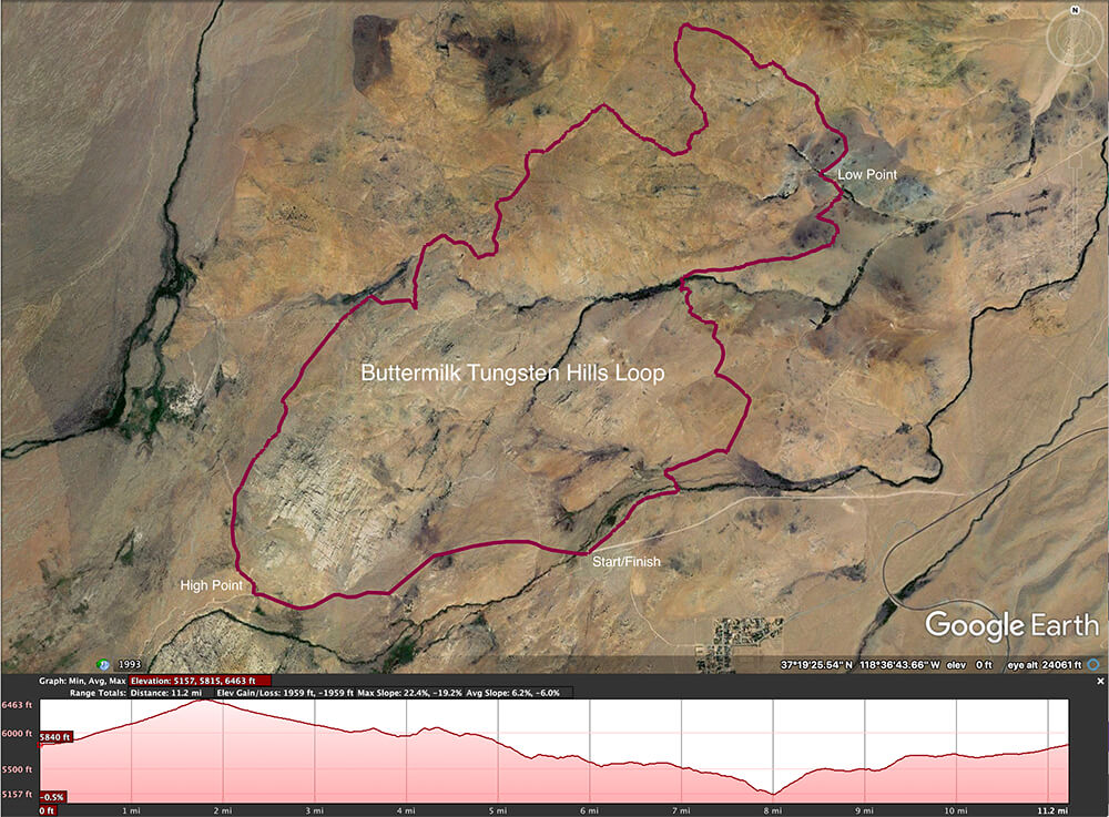
Buttermilk Country and Tungsten Hills
The Sierra Nevada rises dramatically and steeply on its eastern flanks with no real foothills to mark its rise from the lowlands here. The Tungsten Hills and Buttermilk Country appear to be foothills, but they are much older than the massive mountains nearby. These hills are a combination of ancient sedimentary and volcanic rock with more recent alluvial fill and deposits by glacial action from the last ice age. The large boulders that are strewn on these hillsides were pushed by advancing glaciers and then ‘left there’ once the glaciers retreated. At the same time, the glaciers pushed sediment ahead and outward creating the large well-defined moraines, which channel the creeks that flow from the high country.
Buttermilk Country is best known as a world-class bouldering destination and fondly called the ‘milks’ by climbers. The Tungsten Hills are a historical treasure trove of old mines and geological features and the old miners’ roads are now wonderful OHV dual-tracks and dirt bike trails. It’s also a rock hounding delight.
Covering almost 20 square miles, this area is a geological marvel. And it’s an incredibly fun and beautiful area for mountain biking. It’s close to town, but it feels ‘way out there’ and the spectacular views are like nothing anywhere else in the world.
The Buttermilk Rd that provides access to much of the southern side of this area is a wide, graded, and well used dirt road. It does sometimes develop rutting and washboarding and yet it is still a remarkably beautiful road that takes travelers into this land of wide-open spaces and incredible vistas. The northern side of these hills can be accessed by Tungsten City Rd and Round Valley Tungsten Rd. These too are good dirt roads that skirt the base of the Tungsten Hills giving access to an ancient environment of extremes and contrasts.
Mountain biking trails and routes in and around these hills are best in the cooler months of the year. Basically … avoid summertime unless you truly love a hot, dry desert. There’s a lot of elevation change and the routes are a combination of dirt road, jeep tracks, and single-track. Beware of other trail users, especially dirt bikers, and hikers with dogs.
We’ve outlined a good selection of routes and made start and finish suggestions to get the best ride of each. This area is best for intermediate to advanced riders. All these routes can be done in many combinations and there are still more tracks and trails to be explored.
To download the .kml for all the rides listed below, jump to the bottom of the page

Biking is big in Buttermilk Country

Buttermilk Country & Tungsten Hills routes overview
The Big Easy

Length: 16.4 miles
This ride starts at the junction of Buttermilk Rd and SR 168. The first 3.5-miles follows Buttermilk Rd, which climbs just a little shy of 1,000 feet along this well used main route into the Buttermilk Boulders climbing area. Take a right turn as if to go the climbers parking area, then just cruise on by as the road begins to drop down on the west side of the ‘milks’ for about 1.5-miles. At the 5-mile point take a sharp left and head west toward the creek for a little less than a mile. Here the road turns north (right) and drops down about 1,600 feet in the next 5-miles.
Few vehicles use this road and it will be much narrower and may present some fun sandy and / or rocky obstacles. At speed this can feel pretty technical, depending on your skill level, but it’s also a super easy ride at slower speeds.
Passing the old mine digs where a steep switchback heads up into the Tungsten Hills the road curves around the north end of the hills. At mile mark 9.9 cut across a large, tracked, sandy embankment and follow the single-track trail that hugs the base of the hill. It jogs up, over, down, and around the rocky outcrops for a couple of miles.
Rounding the hill, there’s more up-n-over, around-n-down, and then a dip through a wide sandy wash. From here it’s a rough and rocky climb of about 3-miles and 1,000 feet back the start, the last mile of which is a bit of a slog on jeep track.
This is a great ride in the cooler months of the year if you want a couple of hours of fairly easy riding with a sprinkling of challenge here and there. Take plenty of water and wear sunscreen.


Buttermilk Tungsten
Length: 11.2 miles
A great starting point for this (and a number of routes in this list) is 1.8-miles from SR 168 along Buttermilk Rd. Park in an obvious clearing a couple hundred feet from McGee Creek. Begin riding west on Buttermilk Rd toward the Buttermilk Boulders and, just like the Big Easy ride, turn right and pass beyond the climbers’ parking area and head down the trail. At 3.38-miles from the ride start, turn right up the hill and in a 1/4 mile keep a look out for single-track heading sharply off to the left.
This is a super swoopy ride of 1/3 mile back down to the jeep track. After short climb the trail rolls arounds the rocks and down across the hillside for 4-miles. The route drops onto the hard-packed dirt of Tungsten City Rd and into a deep canyon. At mile point 8, turn right onto a well-used old mine road. Keep going, follow the S‑bend, and look for a single-track trail climbing up out of this canyon heading south.
Climb about 400 feet in the next 1/2-mile, level out for another 1/2-mile, then climb up alongside the old mine digs of the Lucky Strike mine. Then it’s pretty much a rolling cruise back to the start. There are many tracks and trails in this area, so be sure to plot your exact route when you ride. Or you may end up at a dead-end overlook or old mine site.

Buttermilk Country
Length: 6.18 miles
This ride begins just like the Big Buttermilk Tungsten Loop. Start on Buttermilk Rd, at the McGee Creek crossing, ride past the climbers’ area and cruise on down the west side of the milks. At mile point 3.65 continue on USFS Rd. 31E307 as it skirts the north side of Buttermilk Country and drops down to the lowest point of the ride at McGee Creek. Then in 1/2-mile the route ends back at the starting point. There are a few optional routes along the north side of the hill and they’re all rolling, fun stuff.
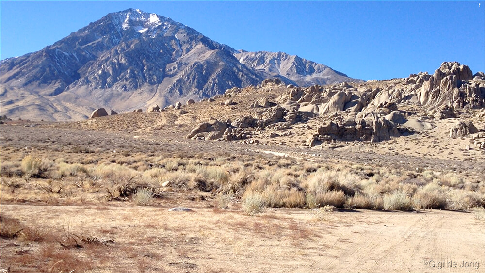
Buttermilk Country view with Mt Tom
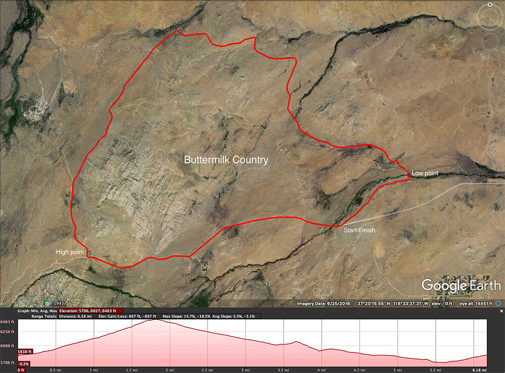
Buttermilk Country map & profile
Cream’s on Top
Length: 4.42 miles
Begin on Buttermilk Rd. at the same spot where the Buttermilk / Tungsten loops start, cycle about 1,300 feet west on Buttermilk Rd. then take right onto a jeep track and roll out through the sagebrush. At .9-mile the track does a 90 deg right, then at mile 1.1 a sharp left to start a steep climb of 290 feet in a 1/2-mile. Then ease on out right around the hill and back down to the creek and the start/finish point. Here’s the .kml track.

Biking Buttermilk Country with my best friend
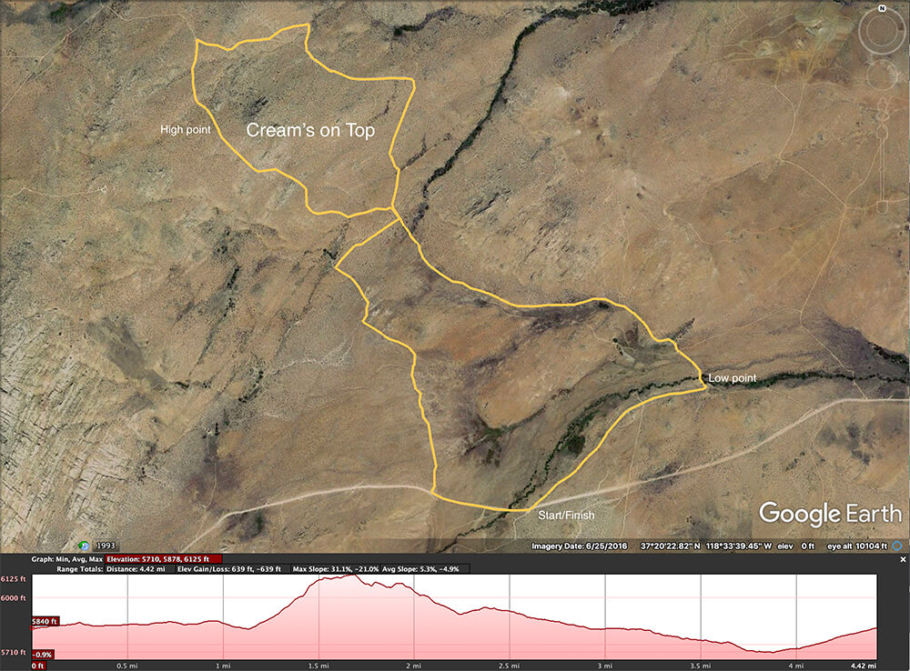
Cream’s on Top map & profile
Whey Easy
Length: 2.81 miles
The start for this quickie is 1.15-miles from the junction of Buttermilk Rd. and SR 168 and park in the turnout at a jeep track. Cycle toward the creek, which can be wet and icy in winter, so cross with care. Then loop around the base of small hill for less than 300 feet of elevation gain/loss in less than 3-miles. Whey easy, right?

Whey easy cruisin’

Whey Easy map & profile
Lucky Strike
Length: 3.42 miles
From another of the many jeep tracks that turns off from Buttermilk Rd. (this one is 1-mile from SR 168) is the start for this ride. Turn onto the track and park in the clearing 250 feet in. Cross the river and ride toward the hill. Take a left turn at 1,200 feet along and follow the track as it traverses along the base of the hill. At mile 1.3 take the track to the right and, after a short dip alongside the wash, keep right then left with the trail and climb to the top of the hill and ride around the north side. Then roll on by the old Lucky Strike mine at mile 2.5, maybe take a quick detour of about 1,000 feet due north to check out the old mine site, then coast back to the start.

View from the Tungsten Hills
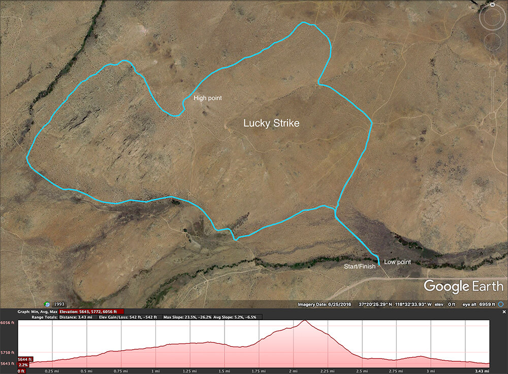
Lucky Strike map & profile
Peeking at Tungsten
Length: 11.5 miles
At a jeep track that turns off from Buttermilk Rd., 3,000 feet from SR 168, is a long loop that climbs and dips through Buttermilk Country then cruises down and out across the Tungsten Hills. A short side trip at mile 7 gets a peek at Tungsten Peak, which, although almost 600 feet lower than Buttermilk Hill, has a commanding view of the surrounding landscape.
Round out the ride with a fast drop into the wash below along a well-used dirt road. Beware of fast‑moving vehicles. At the lowest point, at mile 8.55, take a sharp right that looks as if it’s going nowhere, but follow the switchbacks and climb up an out to the south, west, and south again. Ride around the Lucky Strike, still climbing and then drop a 1/2-mile back to the start.

Peeking at Tungsten map & profile
Between Two Hills (BTH)
Length: 11.2 miles
Between the Buttermilk Hills to the south and the Tungsten Hills to the north are a few more ways to link up these great tracks and trails for more fun and challenges. And to change it up a little the start/finish point for this big BTH loop is from Tungsten City Rd.
Park just off Tungsten City Rd. where it enters the deep ravine and begin the ride on the jeep track that heads south. It’s a long steady, and sometimes steep climb, into Buttermilk Country.
This route connects the tracks and trails described in the shorter routes above and the best way to stay on track is to study the map and download the gps track. On the west side of the hills the route drops down in the Horton Creek drainage then climbs back up along the old mine road switchbacks, out across the hills, and back to the start.
Lop a third of this loop off and do the BTH East, which also starts off Tungsten City Rd., or the BTH West, which starts with the switchbacks from Round Valley Tungsten Rd. on the westside of the hills.

Between Two Hills map & profile
BTH East
Length: 8.59 miles
Begin this ride where the big BTH loop starts and enjoy the steady climb through Buttermilk Country.
At 3.75-miles, where the big loop would go down to Horton Creek, turn north and dip and weave through the rocks for a further 3/4-mile. Then a gradual descent for 4-miles winds around and down the hills back to the start.

BTH East map & profile
BTH West
Length: 7.93 miles
The route begins with the big switchbacks on the west side of the hills. To get the start point drive west from Bishop to S. Round Valley Rd., and turn south onto the dirt road, Round Valley Tungsten Rd.
Hug the north-west base of the Tungsten Hills until the old digs and scarring on the hillside is visible on the left. Park in any of the clearings at the base of the switchbacks.
Start up the switchbacks and follow the obvious dirt track up the hill. At mile 2.3 take a hard right and just keep climbing. There are few dips and drops here and there, but mostly it a climb for 5.7-miles. The a steep descent for 1/2-mile down toward Horton Creek, then a sharp right and it a steady downhill for 2-miles back to the start.
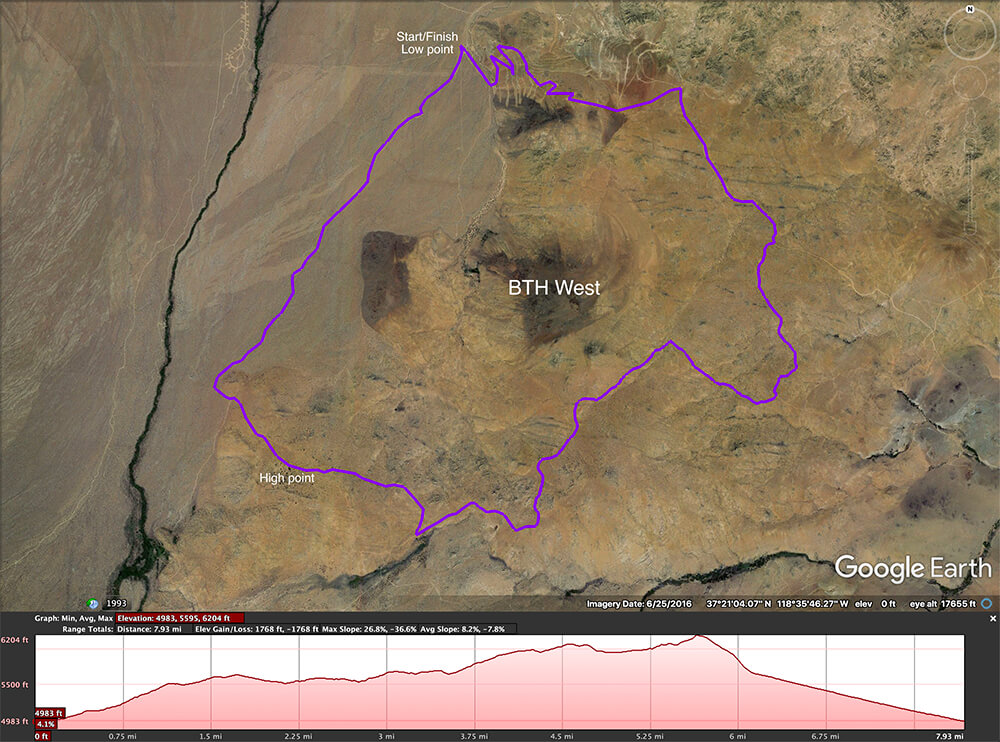
BTH West map & profile
Little Shot

Length: 5.23 miles
A large sandy embankment marks the start of this ride just off Round Valley Tungsten Rd. Cycle west and south along the dirt road at the base of the hill and lookout for track at mile 0.8 that cuts up into the hills to the old Little Shot mine.
Climb above and beyond the mine on a set of switchbacks and follow the obvious road to mile point 2.8. Turn left and ride a little higher to the crest of the route at mile 3.12. The track begins to narrow and weave tightly through the jagged rocks of the north side of the Tungstens. Make a sharp left mile 4.95 to run out through the large sandy embankment. This is a pretty technical ride toward the end.
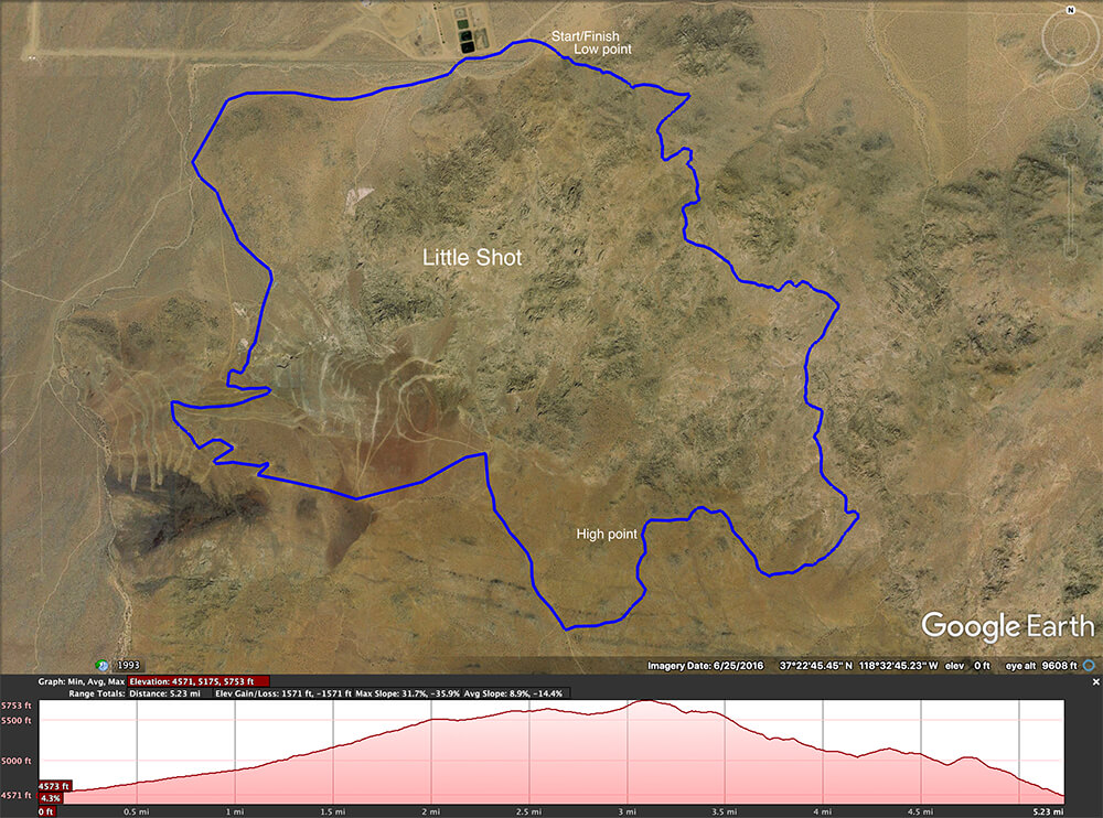
Little Shot map & profile
McGee Creek
Length: 5.15 miles
On the south side of Buttermilk Rd. is a secluded, greener ride into a canyon below Grouse Mountain. It starts at the McGee Creek crossing on Buttermilk Rd, 1.8-miles from the junction with SR 168. Cycle south-westerly on the dirt road that flanks McGee Creek for about a mile. Then follow the wash south as it climbs toward Grouse Mountain.
At the 2-mile mark, the track takes a sharp right and dives down into the canyon on steep, sandy, twisty descent of about 40 feet. At the bottom take a left and go to the turnaround at the head of the canyon … and turn around. Head north-easterly, keeping left along the hillside. In a couple of sweeps around the hill, and a splash across the creek, the trail dumps out onto Buttermilk Rd. Turn right, and one more mile and it’s back at the start.

McGee Creek map & profile
Lower Rock Creek
Length: 7.78 miles
(Stage 1 = 2.1 miles. Stage 2 = 1.1 miles. Stage 3 = 4.58 miles.)
Just a 25-minute drive from Bishop is Lower Rock Creek trail. This incomparable trail has a little bit of everything – fast, sweeping turns, rocks and roots to negotiate, overhanging tree arbors, steep-sided canyon walls, a talus field, and a swift stream with low, wooden bridge crossings. Drive north on US Highway 395 from Bishop for 22 miles then turn left onto Old Sherwin Grade Rd. In 400 feet pull over right and park in the clearing for the Lower Rock Creek upper trailhead.
There are three stages, each getting progressively more difficult. The first two are moderately challenging and well suited to MTB riders with some single-track trail experience. Each stage ends at a crossing at the paved road running down the canyon. At the end of stage 1 or 2, ride back up the road to the start at the upper trailhead or arrange a shuttle pick up by friend or family member. Stage 3 is a technical all-or-nothing commitment. The trail flows down, between, up, and over rocks at the bottom of a deep, narrow canyon that runs way down the escarpment to the lower trailhead in Paradise. A pickup or shuttle ride back to the start at the upper trailhead will be needed when riding the full trail.
This trail is best during fall as upper stages weave through aspen and alpine forests and under glowing tree arbors. It’s also enjoyed by hikers and anglers and dogs are welcome here too. So be prepared, be vigilant and be safe.

Wagon Wheel
Length: 4 miles
This trail runs along a bit of fascinating Owens Valley history. In 1870 James L.C. Sherwin made a rough road from Sherwin Meadows, which is now the settlement known as Swall Meadows, to haul lumber down to Round Valley. Some years later he built a toll road, the High Road, that connected Round Valley with the historic Mammoth City. For many years, huge mule-drawn wagon trains weighing many tons cut through the Bishop Tuff, which is the volcanic rock that forms this massive escarpment. Their passage left deep scars in the rock and this is now part of the current Wagon Wheel biking and hiking trail.
Begin the ride at a sandy clearing above Swall Meadows, on Sky Meadow Rd., and weave down a narrow, sandy canyon for about a mile to a crossing at Swall Meadows Rd. Turn left onto the road and ride about 250 feet to a small turnout on the right (south) side of the road. Cut across the turnout and through the low rocky barrier onto the trail. Then head out onto the wide bluff that drops over 1,000 feet in 2.5 miles of technical terrain that runs through a number old wagon train ruts. The trail runs out through a wide, sandy depression at the north-west side of the settlement of Paradise. Hop onto the old Sherwin Grade road and coast the last .5 miles to the Lower Rock Creek trailhead.
This is a great downhill ride with a shuttle pick up in Paradise. Or park a vehicle at the sandy washout above the town and start the ride with an uphill climb to the junction of Swall Meadows Rd. and bomb back down the trail. That’s a total ride of 5-miles with 1,000 feet up and 1,000 feet down.
This is rideable all year, depending on winter snowfall. The upper portion above Swall Meadows Rd. may be under snowpack in heavy snow years.

Deep cuts in the rock made by wagons over 100 years ago.

Wagon Wheel map & profile
Owens River Meander
Between Poleta Rd (E.Line St) and Warm Springs Rd is a sinuous section of the Owens River where a bike ride on a typical winter day in Bishop is simply stunning. Spring and fall are gorgeous too.
This route has diverse terrain – soft sand, short grass, hard-packed dirt, paved road and a sand dune! It also skirts the beautiful Buckley Ponds where there are places to stop and rest and enjoy a snack. See red tail hawks soar above the plain and great blue herons rise languidly from the tall reeds along the banks. It’s a wonderfully relaxing ride for experienced riders and a safe challenge for youngsters and less experienced riders. There’s not much elevation change, but even so, everyone should have a reasonable level of fitness and basic bike handling skills. It can get a little energetic in a few places.
Drive east on E. Line St. for 3 miles from the intersection with Main St. in Bishop. Just before the bridge that crosses the Owens River turn right onto a wide dirt road and park in the clearing on the left. Cycle up on the paved road, named Poleta Rd. here, and cycle across the bridge over the river. 600 feet beyond the bridge turn right onto a dirt track south-east across the river’s old floodplain. At mile point 0.83 from your ride start, turn right on a sandy track toward the river and weave alongside the snaking waterway for 3-miles to where the track meets up with Warm Springs Rd. Turn right onto the roadway and cycle over the river and beyond the river’s riparian edge. At mile point 4.18 turn right on the wide, graded dirt road and begin the return journey. At large clearing, at mile mark 4.5, turn left (west) to stay on the road to the Buckley Ponds. Keep alongside the canal to the left and ponds to the right for a leisurely cruise by the water.
Just beyond the ponds, at mile point 6.82, turn up onto a sandy track for the only real climb of the ride. It may even require some pushing if the sand is dry and deep. Head due north until the start point is in sight on the right, then take a slippery, slide down the sandy dune back to the beginning.
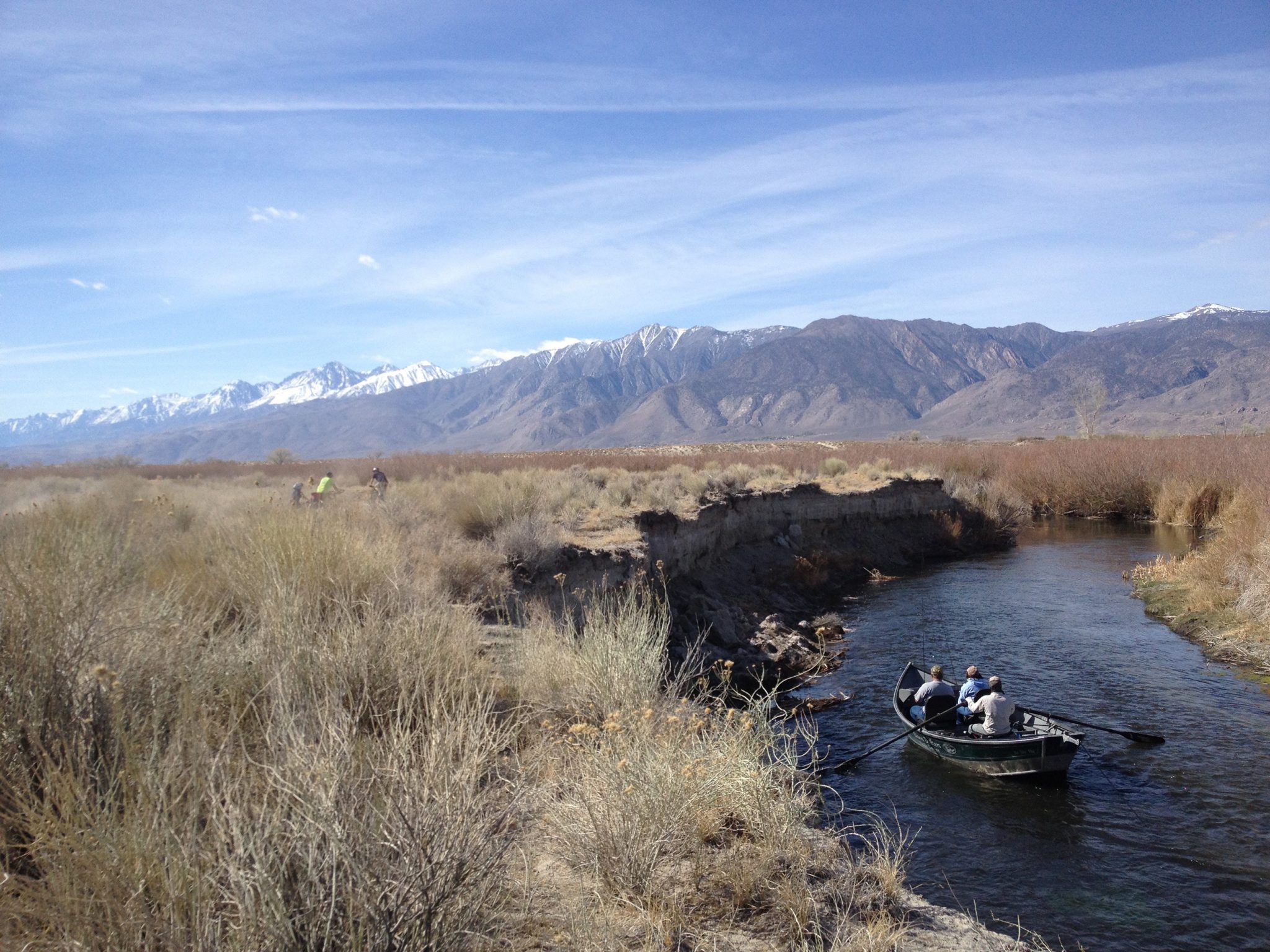
Cycling alongside the Owens River while boaters float by.

Owens River Meander map & profile
Pipeline
Length: 10.5 miles
It’s about 10 miles of mostly downhill mountain biking that starts just off Highway 168, opposite Intake II reservoir, near Aspendell. In winter and late spring, a 4×4 vehicle may be needed to get to the start point if there is snow on the ground. In heavy snow years, the start may be completely inaccessible. This route is great on a fatbike. In winter it’s likely to have snow near the top and it always has deep, soft sand toward the end of the trail. But it’s no problem on a regular mountain bike, which is super fun to slide around the corners.
Head east out of Bishop on Highway 168 toward Aspendell. Drive 14.5 miles and Intake II and its parking area come into view on the left … slow down! Look to the right for a (not very obvious) dirt road heading up onto the moraine. Turn right and follow the road for about 500 feet and park to the right of the clearing.
This ride will require a shuttle to take a vehicle to the finish point or a lift up to the start point to retrieve a vehicle. In summer the Eastern Sierra Transit Bishop Creek Shuttle to Lake Sabrina does make intermediate stops along the way. The afternoon run which leaves Vons in Bishop at 4pm, may be just the ticket to get a ride to very near the start point for this ride.
From the clearing at the ride start point, begin cycling up the obvious track as it traverses and climbs the moraine – a little over 200 feet in a little less than a mile. Crest the moraine and drop down the west side for about 650 feet then make a sharp right, then a quick S-bend left and right, and now keep heading straight down. At mile mark 2.34 keep right at the fork to stay up on top of the moraine. Then the trail goes through a sandy wash to meet up with the main road at mile mark 7.5. Watch for traffic on this blind corner, then cruise up the road for 1,000 feet. Just beyond the Armco barrier on the opposite (east) side of the road, a track cuts up the berm then drops down in a narrower, sandier gully. A lot of good sliding happens here.
The last mile opens out across the high desert scrub along wide dirt roads near the power plant on E. Bishop Creek Rd. Finish up at the junction with SR 168 (W. Line St.) at the Bishop Creek Battleground Historical Landmark.
Remember to dress in layers. It may cold at the start and hot at the finish.


Mobius Arch loop
Length: 5.1 miles
This route weaves through an incredible landscape of beautiful rock formations, bordered by a vast open plain that rises majestically to snow-capped mountains and the highest peak in the contiguous United States, Mt. Whitney. It has super single track, a fun stretch of hard packed dirt road, and a few rocky steps where the bike will need to be carried.
From the heart of Lone Pine (a beautiful 60-minute drive south of Bishop) go west on Whitney Portal road then, 2.7 miles along, turn right onto Movie Flat road. Two miles further turn right at the T and immediately turn into the cleared parking area for the Mobius Arch trail.
Begin the ride from the west end of the parking lot and follow the trail down a short, steep slope. At the bottom, cross the dry wash and keep left onto a trail marked for hikers, bikers, and horse riders. DON’T take the right-hand trail to the Mobius Arch! That will be the reward at the end of this ride.
Follow this great single track between the rocks, across dry washes, and through the sagebrush for about 1.3 miles. At an obvious dual-track road, turn right and enjoy the sweeping, swooping turns over rock and through some sand.
At mile 2.2 this track meets up with Movie Rd., a wide, graded, but somewhat washboard road. Take a right turn and head up the hill for a mere .5 mile climb then cruise downhill, more or less, for 1.6 miles. Keep a lookout for a small trail marker to the right at 4.3 miles from the start. Head off down this single track. In about 600 feet keep left and in another 600 feet keep right. The trail isn’t very obvious in the deep gravelly stuff, but even getting lost out here is fun.
Once again, the trail weaves among the rocks and soon a directional sign will point the way to the Mobius Arch. The last few yards will be a portage up some rocky steps and voila! there it is. The Mobius Arch. Leave bikes below. Climb up. Take photos. The arch almost perfectly frames Mt. Whitney in the distance.
Return to the start point by continuing along the loop trail past the arch, down across the wash, and up the slope to the parking lot.
The Alabama Hills is a fascinating exploration of natural and cultural history. Make day trip here and visit the Museum of Western Film History and learn all about this magical movie place – celebrating Hollywood culture.


KML Downloads
Download a .kml file for each of the above rides to your device here and stay on track!
To convert the .kml to another gps file format we recommend GPSBabel. Download and use for free.