Hidden Pioneer History of the Owens Valley
By Joe Pollini – Bishop Chamber of Commerce
So you want to experience the early pioneer life of the Owens Valley? Want to fascinate yourself with unique characters, stories and personalities that legends are made of? If so, dive deep into our history which embodies the “rough and tumble” 1880’s frontier towns of the American West. Explore Owens Valley’s hidden history and travel to the late 1800s to create a vignette of the valley’s historic towns, people, and features to uncover what dreams lured miners, pioneers, merchants, farmers and residents to the region.
Carve out a self-made adventure to experience forgotten frontier stories as you discover and seek out locales and cultures that have decayed, vanished, or been replaced by other communities. And why certain settlement locations were preferred over others.
Most sites have little to no physical evidence of their story while a few have preserved the era’s Wild West frontier spirit in perpetuity.
The locales described below arose from an insatiable lust for riches and opportunities that was beneficial to some settlers but dismal for most. The “pot of gold” at the rainbow’s end benefited farsighted entrepreneurs including farmers, ranchers, and numerous merchants who followed prospectors to provide them with food and subsistence. This enterprising group gained the most financially while many hardscrabble fortune hunters seeking mineral wealth died penniless.
The two mile deep Owens Valley, aka “The Deepest Valley”, is bounded to the west by the Sierra Nevada mountains and the east by the White Mountains. The White Mountains begin the high-desert Basin and Range that continues through Nevada easterly into Utah. The fertile Owens Valley attracted many frontier pioneers, prospectors, and settlers with dreams of wealth. Early frontier folks, like locusts, also migrated into nearby Fish Lake Valley, Panamint and Death Valleys – – – to the east and south; with others sought fortune to the north in Benton, Queen Valley, Adobe Valley, Long Valley, Mono Basin and the Bodie Hills.
An interconnected stepping-stone of civilization outposts in this wilderness reached as far north as the Virginia City’s Comstock Lode that was then a part of the Western Utah Territory. In the latter half of the 1800s, many dozens of locations, settlements, and transportation hubs formed a tapestry characterizing subjugation of America’s wild frontier in this region.
In 1880, the census determined that the Owens Valley supported almost 3,000 residents.
“The Mountains are filled with timber, the vallies with water, and meadows of luxuriant grasses (sic). Some of these Meadows contain, at a moderate estimate, ten thousand acres, every foot which can be irrigated (sic).”
– Captain J.W. Davidson’s Description of Southern Owens Valley During His 1859 Expedition.

1864 Owens Valley Mining Map. Courtesy of Owensvalleyhistory.com

Our story begins with one of the first settlements of the Owens Valley — Owensville . . .
Click on each toggle bar below to open a whole world of historic possibilities …
Owensville
 A. Van Fleet built a sod and stone dwelling along the Owens River in 1861 to begin a cattle ranch to feed Owens Valley miners. A few years later, mineral discovery in the adjoining White Mountains drew prospectors to settle this locale dubbing it Owensville. Owensville became one of the first of several river towns sprouting up along the river that provided fresh water, a transportation commercial lifeline, and proximity to nearby mountain minerals.
By late 1862, the community was morphing into one of the largest settlements in the valley. One family wrote to the San Francisco newspaper, Alta, and proclaimed “I have just arrived with a party of 56 men, one family, 82 yoke of oxen and saddle horses innumerable. The valley contains 52 claims of 160 acres each . . .. Just heard of 40 men, all farmers, and twelve ox teams, who have arrived”.
With a brief lifespan of bustling growth beginning in 1863, town property values and foodstuff prices soared. Corner real estate lots skyrocketed to $1,500 while sacks of flour commanded $20 each. The mountains however failed to yield riches miners craved. The town withered away quickly with the last resident departing in 1871. The region’s scarce lumber was in such high demand that it motivated enterprising individuals to salvage timber from town buildings, shipping it downriver to Independence and Lone Pine. Many residents who vacated Owensville moved to nearby Bishop Creek, the frontier town that became present day Bishop.
The site has all but disappeared. A historic monument lies along Highway 6 before the Laws Historic Village entrance.
Laws Railroad Museum & Historic Site

1883 Carson & Colorado Railway Map. Map Courtesy of Carsoncolorado.com.
Laws is one of the few remaining Wild West valley towns. The Bishop Museum and Historical Society assembles and preserves antiquities of frontier life for visitors who appreciate history and desire to travel back in time.
Developed in 1883 as part of the Carson & Colorado Railway investment scheme to service the original mines along the east side of the Owens Valley, the rail line ran from Mound House, Nevada to Keeler terminating on the east shore of Owens Lake in Keeler.
The railroad subsequently increased its rail line into Southern California in the early 1900s and expanded its operations to transport passengers and freight such as agricultural goods.

Relive history and take a ride on a 1920s Motor Car. Photo by Joe Pollini.
Laws became a pivotal railroad town along the original 300 mile stretch of rail line before expanding into Southern California. It was named after R.J. Laws, an assistant superintendent of this railroad stop in 1900. After the railroad line was completed in 1883, one of the financial partners rode the train from Mound House to Keeler to check out the value of his investment. After a long, dusty and bleak expanse of desert travel, he wryly noted “. . . it seems to me we have built the railroad 300 miles too long or 300 years too soon”.
Nonetheless, the railway along with Laws thrived and sustained the Owens Valley economy for decades. The rail line was a narrow 3.5 feet in width or gauge, and the train riding these rails was dubbed the “Slim Princess”.
It took three days of rail travel to reach San Francisco while a stagecoach to Los Angeles would take about twelve. The rail line became a connecting link between an isolated valley and the rest of the world. Typically, cattle, farm produce, and passengers were hauled to the north with rail operations fully ceasing in 1960. Imagine yourself living well beyond the edge of civilization where it requires days of travel to get to a big city and your conveyance has no air conditioning, reclining chairs, coffee shop, lounge car, Wi-Fi, or electricity.

Laws Railroad Depot. Photo by Joe Pollini.
Visit this 11 acre frontier village and plan a few hours to experience several original features from the late 1880s as well as an abundance of historic exhibits, displays and original architecture reflecting the Owens Valley frontier culture. Check out the historic wagon depot where the iconic 1960’s western, Nevada Smith, was filmed.
The Laws village is located off Highway 6, about 5 miles north of Bishop.
Tungsten City
How would a small “pop-up” town in the middle of a dry, barren patch of hills become so important to the World War I effort? Read on to find out . . .
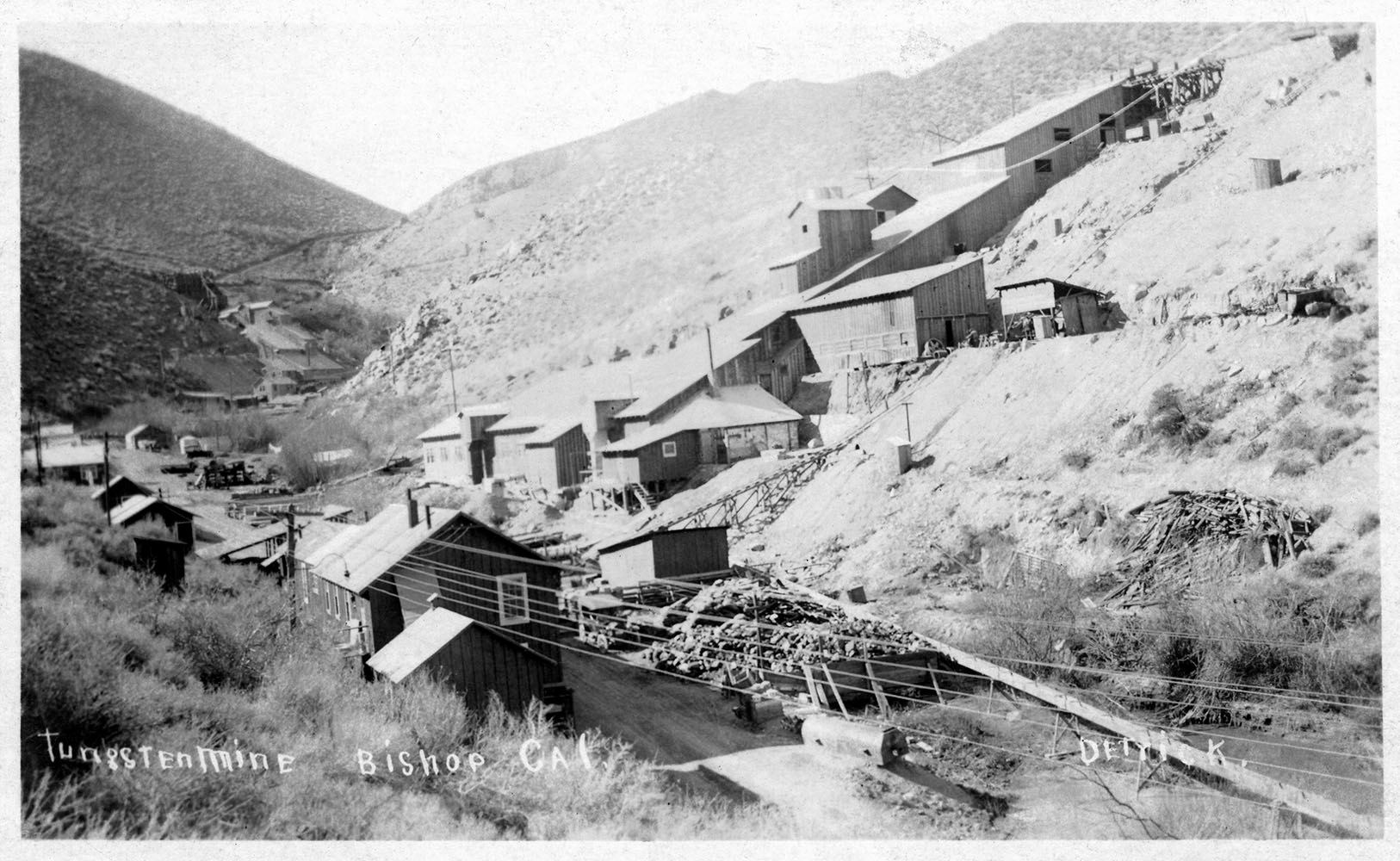
Tungsten City Mill. Photo courtesy of Owensvalleyhistory.com.
The Tungsten City area, associated mines and mill sites flourished in the early 1900s when three prospectors accidentally found scheelite, a tungsten ore. Discovered in the Tungsten Hills in 1913 about 5 miles outside Bishop, tungsten was in high demand during World War I. Its unique properties to harden steel became indispensable for tanks, battleships, and other war machines production. This demand propelled tungsten prices to the stratosphere.
One of the prospectors, Jim Powning, shot a rabbit for dinner one evening, and when he retrieved his prize, he found Scheelite. He called this mine location “The Jackrabbit Mine”. Promptly, the three men staked out fourteen mining claims. Others located more claims in the immediate area.
As the war came along in 1916, tungsten demand and prices skyrocketed. More claims were filed with tungsten strikes outside Big Pine, 15 miles south of Bishop, setting off a rush of mining claims and diggings that stimulated Owens Valley’s economy for several years. The notion of quick wealth motivated many locals to go out with pick and shovel to strike it rich. In 1916, The Owens Valley Herald noted that three men in just two hours unearthed $100,000 (in today’s dollars). The Los Angeles Times captured the fervor of the craziness with multiple headlines: “Tungsten Find Incites Rush”, “Town Virtually Deserted as People Go Mine Mad”.
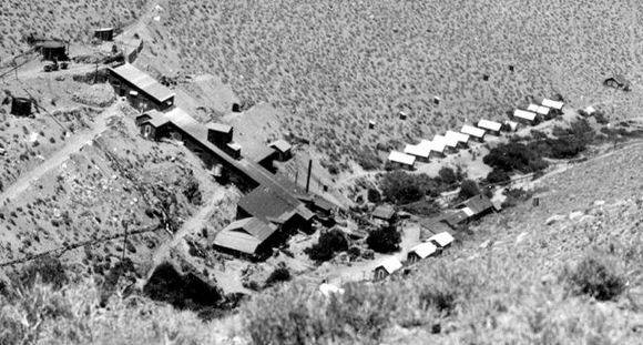
Tungsten City Mill and Cabins. Photo Courtesy of Owensvalleyhistory.com.
New housing was needed for up to 600 new residents. In 1918, investors constructed Tungsten City near a 300 ton mill facility to meet that demand until the tungsten market went bust some years later. The 300 ton mill was hauled in by rail to Laws, then carried by wagon in pieces, and assembled in the Tungsten Hills. It was considered the largest mill of its kind in the country.
Little remains of the town except for old road cuts, mine shafts and tailings, decaying cement foundations, and scattered scraps of metal waste.
Cardinal Mine

Gaylord Wilshire – 1924. Courtesy of Laconservancy.org
How would a famous Los Angeles resident, the namesake for a major boulevard lined with expensive real estate, go broke in the Eastern Sierra? Read the fascinating story behind this mine . . .
Originally titled the Bishop Creek Mine, production began in the late 1880s producing small amounts of gold. Gaylord Wilshire, whose name is connected to Los Angeles’ Wilshire Boulevard, purchased the mining claims in 1906 and proclaimed them as “The Greatest Gold Mine in the World”.
Wilshire was a capitalist investor using his financial gains to support socialist causes. He started a socialist magazine, “The Challenge”, and at its peak reached over 400,000 subscribers. When the magazine declined, his interest in mining led him to purchase the claims in Bishop Creek Canyon.
Wilshire invested heavily in his mine making various improvements. He developed a village near the mine to support his workers. In 1913, the mine produced over 1 million dollars of gold in 2014’s dollars. He built a hydro power plant using North Lake to electrify the mine, community and an extra heavy 10 stamp mill to process the mined ore.

Cardinal Mine Head Frame. Photo by Joe Pollini.
Construction and housing flourished during his tenure. Wilshire wanted to build a socialist utopia at the mining camp supporting 300 to 400 socialists employed in summer. But he never achieved his dream, employing about fifty miners maximum.
The mine failed to yield the results Wilshire envisioned, though. He couldn’t generate enough gold to pay back the stockholders; the mine went into receivership and was leased out to Consolidated Metals Corporation in 1927. Wilshire passed away in the fall.
The Cardinal Gold Mining Company purchased the property outright in 1933, renaming it and improving production efficiencies. In 1934, it produced more gold than any other gold mine in the United States. By 1937, it was employing almost 100 men, and considered to be one of the top ten producing mines in the country. It successfully operated until 1938 when gold seams ran out.
Catch the scenic overlook and historic monument of the mine ruins on State Highway 168 one mile west of Cardinal Road in Aspendell.

Bishop Creek Mine 1911 Stock Certificate Issued by Gaylord Wilshire. Courtesy of Owensvalleyhistory.com
After the overlook, return to Cardinal Road, turn left and drive to the Cardinal Village Resort Café to get mine information and inquire how food was refrigerated at the nearby 1895 Meat House without electricity. The mine itself has cement platforms, a dilapidated head frame, mill and cyanide plant ruins, road cuts and mine debris lying about. Cardinal Village Resort has refurbished nine original cabins built in late 1800s and early 1900s to rent to visiting guests.
Zurich/Alvord

Zurich Railroad Depot. Photo Courtesy of Owensvalleyhistory.com
Zurich, originally constructed and named Alvord in 1884, was a railroad stop south of Laws along the Carson-Colorado Railroad. Located 2 miles northeast of Big Pine east of the Owens River, it served as a siding station supporting a few railroad buildings including the railway agent’s house. Local teamsters hauled freight and passengers between Big Pine and Alvord.
The railway agent’s wife who immigrated to the area from Switzerland was so enchanted with the snowy Sierra which reminded her of home that she convinced her spouse to change the name. The railway agent promptly changed it – – – cognizant that “happy wife meant happy life”. Some things never change . . . .

Historic Monument Photo by Joe Pollini.
Deep Springs Valley Toll Road Station

Tollhouse Stop. Photo by Harry Mendenhall. Provided Courtesy of Eastern California Museum.
In the 1860s, soldiers stationed at Owens Valley’s Camp Independence needed access to Fort Churchill in Nevada — requiring passage over the rugged and steep White/Inyo Mountain Range. They built a temporary rough wagon road through a canyon they named Soldier Canyon. Several years later, three entrepreneurs built a better road east of Big Pine where Highway 168 currently lies, improving access for settlers, miners, and others. The old road was abandoned. To offset the construction costs of their investment, they charged a toll to users and provided water and shade.

Family Outing at Tollhouse circa 1917. Photo Courtesy of Deep Springs College.
Today this spring fed oasis contains an information sign, a fresh water spring and water trough.
Fish Springs & Black Rock

Cometti Mine Water Wheel – Fish Springs Hill. Photo Courtesy of Eastern California Museum.
Fish Springs is located about 7 miles south of Big Pine while Black Rock is located several miles further south. Both communities began in 1864. Fish Springs was blessed with an abundance of water resources. It was situated west of present day U.S. Highway 395 where reliable spring sources and several flowing Sierra creeks were easily available and utilized. The community was nestled at the north edge of the Poverty Hills and east of Fish Springs Hill, where several small gold mines operated. According to local legend, the Poverty Hills was named by a shopkeeper who went broke when prospectors couldn’t pay their bills. Fish Springs had a notoriety for using water, in lieu of pack stock, to crush ore rock in arrastras. Black Rock was several miles south with more isolated, scattered structural features along the Owens River as well as Taboose and Goodale Creeks.

Penstock on Sawmill Creek above Owens Valley. Photo by Terry Roy. Photo Courtesy of Eastern California Museum.
By 1870, Fish Springs was the largest settlement between Bishop and Independence; the communities were small but thriving, consisting of miners, farmers, ranchers, millwrights, merchants, stonemasons, teamsters, house wives and children. Approximately, 140 people lived in these communities according the 1870 census.
Farms growing barley, wheat, corn, beans, potatoes, and various vegetables flourished at Fish Springs. Peach, pear, and apple orchards were cultivated in the early 1900s. Lumber, shingles, and cordwood from the three Fish Springs-Black Rock sawmills stabilized mine tunnels on Fish Springs Hill, built homes in Independence, and fired smelters in Darwin. Both settlements became major stage stops for passengers and freight traveling between Bishop and Independence before the Carson-Colorado Railroad began in 1883.
Unlike towns which relied on sole industries such as mining, Fish Springs’ and Black Rock’s commercial diversity stimulated Owens Valley’s frontier economy and settlement. Both communities were a mix of miners, farmers, and ranchers. The towns began to fold in the 1920s as land ownership and the economy began to change.
The site contains a few abandoned irrigation ditches, some stone cabin features, mine prospects/tailings, and agricultural fields covered in rabbitbrush, sage, and debris.
Camp Independence

Camp Independence — late 1800s. Parade Ground. Photo Courtesy of Eastern California Museum.
Prior to the incursion of Euro-Americans in 1492, hundreds of Native American tribes occupied North America for thousands of years. As Spanish, French, and English explorers and settlers sailed over from Europe to find fortune, escape persecution, and seek better lives, they occupied and cultivated land used by Indians for millennia to survive and practice their culture’s traditions. In general, as more of the country became more populated by the newcomers, increased competition for resources such as fur, food, water, timber and land led to inevitable conflict between the prior occupants and the settlers.
The story of the Owens Valley replicates a similar progression of cultural conflict and impact. Food in the valley was meager due to the arid nature of the region. Fortunately, plentiful water from the Sierra supplemented the Native American diet who used ditches and flood irrigation to grow native plants, along with harvesting of local rabbits, deer, antelope, pupfish, pinyon nuts, and other foods. Like the rest of the country, conflict over resources would become inevitable.
Skirmishes between Owens Valley Native Paiutes and new settlers led to the construction of this garrison to house troops who occupied the area on July 4th, 1862. The fort was consequently named after the holiday. Lieutenant Colonel Evans brought about 200 soldiers of the U.S Cavalry to keep the peace. Their presence sealed the fate of the Paiute Natives who had lived peacefully in the valley for millennia.

Camp Independence Adobe Hospital – late 1800s. Photo Courtesy of Eastern California Museum.
In 1863, around 900 Native American men, women, and children were forced to march 200 miles to Ft. Tejon to isolate them from their home.
One Native American described the forced relocation journey in the following way: “The white men proposed peace and arranged a big feast at Fort Independence for all the Indians in the region. The Indians arrived and were at once deprived of their arms. The following morning the soldiers drove them down the Owens Valley and then across the Sierra Nevada to Fort Tejon, a journey of many days. Many people escaped in route and returned home.”
With the original occupants removed, the commanding officer convinced his superiors that ousting the local Natives ensured the valley’s safety and there was no reason to operate the camp. Against the wishes of many settlers, the camp was abandoned for two years. Many Paiutes ultimately escaped their captivity, fled back to their ancestral home and conflict followed, requiring the fort’s reactivation in 1865. It was occupied for twelve more years.
Ruins of Camp Independence. Photo Courtesy of Eastern California Museum.
As more settlers arrived to the valley, the camp became a center of social and civic engagement. A severe earthquake in 1872 demolished many adobe buildings in the camp. The camp was abandoned again several years later with several intact buildings moved to nearby Independence.
All that remains is a historic monument off Highway 395. In nearby Independence, find the Commander’s House and the Camp Hospital. Get more information at the Eastern California Museum on Grant Street.
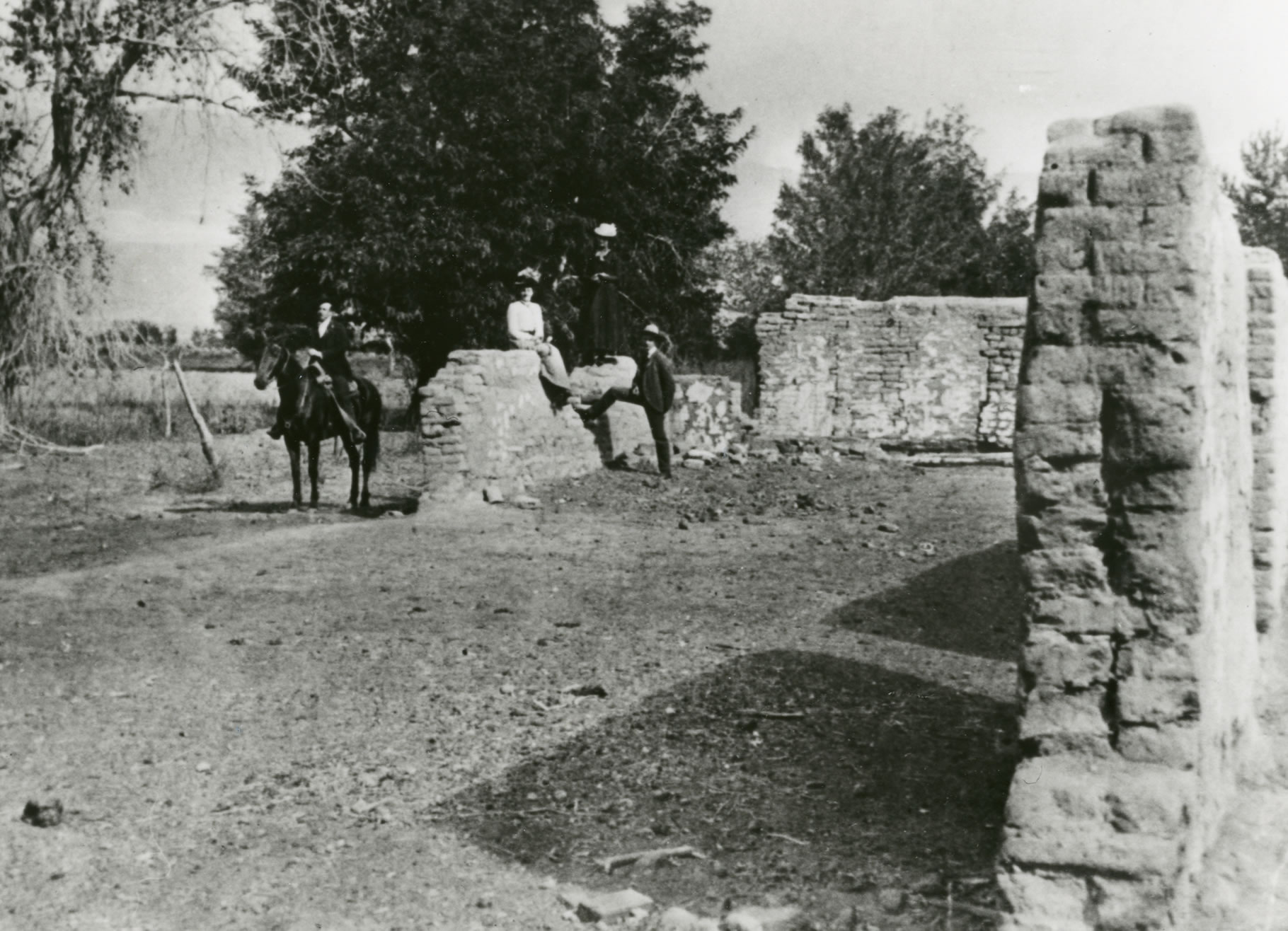
San Carlos & Bend City

Modified Map Courtesy of Ted Williams.
A Camp Independence soldier wandering the nearby foothills in Mazourka Canyon found gold in 1862 creating a new rush of prospectors. San Carlos and Bend City, founded in 1862 and 1863 respectively, formed the communities associated with this discovery.
Both towns were only three miles apart. Their proximity to each other led them to fiercely compete for territorial, economic, and cultural dominance.
Several hundred residents lived in both communities at their height. Bend City built the first bridge to span the Owens River to gain commercial access advantages over San Carlos, while San Carlos was inefficiently ferrying men and horses across the river on crude rafts, pulling them with rawhide rope.
Bend City vied to become the county seat of newly pending Coso County in 1864. Because the election was held on the wrong day, it was nullified, relegating the town’s aspirations to an ash heap of history. Ultimately, nearby Independence would become the county seat of the newly formed Inyo County in 1866.
 The nearby mountains dealt both camps little mineral wealth and by the 1870s the towns declined as residents left for nearby Independence or moved elsewhere. The 1872 earthquake became the final coffin nail for the towns. The earthquake changed the river’s course away from Bend City. The Bend City Bridge now uselessly crossed a dry river bed.
During its heyday, the camps had butcher shops, assay offices, a mill, mercantile stores, a library, saloons, a saddle and blacksmith shop, a tailor shop, a laundry and more. The river towns symbolized “the boom or bust era” of mining that typified many frontier towns.
No physical evidence of either town exists.
Independence

Present Day Inyo Courthouse. Photo by Joe Pollini.
Charles Putnam originally settled Independence in 1861 and referred to it as “Putnam’s”. Later the settlement became known as Little Pine. Putnam began a trading post for miners and others migrating to the valley.

Photo by Joe Pollini.
The settlement grew and when it became the county seat in 1866, when Inyo County was formed, it was renamed Independence after the nearby fort. Ultimately Independence prospered on industries other than mining. Farming, ranching, tourism, and government services diversified its livelihood sustaining its small town economy, ambiance and charm. By 1880, the census identified some 300 residents living in Independence.
Today, the town is a repository of historic features, architecture, and monuments to Owens Valley frontier history. The Independence Historic District contains some forty different homes, buildings, and sites depicting valley history.
Its major historic showcase is the Inyo County Courthouse built in 1922. Of the three earlier courthouses, the first was destroyed by the 1872 earthquake, the second burned to the ground, and the third was not large enough to meet the county’s administrative needs. The current courthouse was added to the National Register of Historic Places in 1992 to honor its “integrity of feeling and association”.

Noted Author Mary Austin’s Home. Photo Courtesy of Eastern California Museum.
Check out the Eastern California Museum, the first in the county, on Grant Street for additional information. At the museum, grab the Discover Historic Independence Walking Guide and find numerous buildings and monuments commemorating area history including the county’s oldest structure known as the Edwards House, the Camp Independence Commander’s House, noted author Mary Austin’s home, the Inyo County Courthouse, and more.
Mary Austin, author of Land of Little Rain, lived in Independence and the Owens Valley in the 1890s. In her book, she described the valley as “a big mysterious land, a lonely, inhospitable land, beautiful, terrible”.
Owenyo

Owenyo Location Map. Note Numerous Railroad Stops Along the Carson-Colorado Railroad Line Between Laws and Keeler. Photo Courtesy of Ted Williams.
Owenyo offered a unique form of housing that also served as a schoolhouse. Find out in the story below where some Owenyoites ended up living.
Quaker colonists of the William Penn Colonial Association first settled the area southeast of Independence in 1900. They purchased 13,000 acres to start a community called Owenyo. Inexperienced with irrigating and working the desert land, the Quakers struggled to make the settlement work. In 1905, the community went broke and sold the property to the Los Angeles Dept of Water and Power, eventually transferring the name Owenyo to a planned railroad transfer station.
Southern Pacific Railroad bought the Carson-Colorado Railroad adjoining the community shortly after to upgrade rail service from Mojave to the Owens Valley and tie into the existing Slim Princess rail line to Mound House, Nevada.
Take a moment and see if you can determine how Owenyo was named? If you guessed that it was a compound abbreviation of Owens Valley and Inyo, you are correct.

Dumping Ore from Narrow Gauge to Standard Gauge Train. Photo Courtesy of Owensvalley history.com.
Owenyo served as a transfer point where standard gauge rails from Los Angeles met narrow gauge rails of the Owens Valley. Freight, commercial goods, and mineral ore was transferred from one train to another at Owenyo due to the incompatibility of the different rail widths. The rails coming up from Mojave was 4.75 feet gauge or width, while Owenyo to Nevada was 3.5 feet gauge. Passengers, travelling from Mojave to Nevada by train, stopped in Owenyo, disembarked from the wide gauge train to then embark onto the “Slim Princess” train to continue their ride north.
Removing and reloading freight between the two railroad gauges was done entirely by hand, although transfer of mine ores was facilitated by a raised trestle that the narrow gauge cars climbed up onto. Standard gauge cars went underneath, then the railroad car dump doors on the narrow gauge cars dropped their ore into the standard gauge cars below. There was a manually operated turntable located near the transfer trestle in which narrow gauge locomotives were turned, standard gauge locomotives were turned on a Y.

Owenyo Transfer Depot in 1947. Photo Courtesy of Eastern California Museum
In the early 1900s, gold strikes in Goldfield and Tonopah, Nevada along with the Los Angeles Aqueduct construction, and the valley’s farm, ranching and orchard exports boosted rail operations for several decades.
At its height, the town had a restaurant, hotel, train yard, railroad station, an ice house, and more. There was no water in Owenyo; it was bought in from a source near Diaz Lake. Ice was used to keep food fresh since refrigeration had not been invented yet. When the local ice house ran out of ice, local youth would go up to Manzanar’s ice facility, purchase more, then haul it back by wagon to Owenyo to sell. The area’s abundance of rabbits also inspired enterprising youth to sell skinned rabbits to trainmen for $0.50 each.
There is no timber around the bleak desert environment of Owenyo to build homes and schools. In lieu of traditional buildings, it was common to modify empty boxcars for residential housing as well as for the local school. Children of Owenyo were taught how to operate trains in the area by trusting railroad personnel. Local kids used hand rail cars to get around to local places like the Owens River to go fishing.
Like Laws, Owenyo became a railroad town relying on a diversity of goods and services to sustain itself. After the 1930s, the town’s commercial operations began to diminish as Southern Pacific abandoned portions of its narrow gauge. Motor cars also began streaming up the El Camino Sierra Highway (the original name for U.S. Highway 395) further west contributing to the railroad’s demise. As with Laws, rail operations ceased altogether in 1960.
Little of Owenyo is visible. Railroad grades of both the narrow and standard gauges can still be found as well as caved in cellars, foundations, metal scrap, fencing, the depression of the narrow gauge turntable, and pillars of the transfer trestle, all laid out over about a half mile square.
Swansea

Bessie Brady Steamship Painting by William McKeever. Photo Provided by Eastern California Museum.
Swansea was a short lived boomtown on the east shore of Owens Lake about 10 miles southeast of Lone Pine. The success of the silver mining operations in the nearby Cerro Gordo Mines in the late 1860s spurred a settlement which became a hub for smelting silver ore and transporting the resulting ingots to Los Angeles, over 200 miles away.

Steamship Navigation Routes on Owens Lake in late 1800s. Map Courtesy of Eastern California Museum.
The port of Swansea was a launch point to transport silver across Owens Lake to Cartago by steamships where the bullion was then loaded on teamster wagons for shipment south. The steamship, “Bessie Brady”, saved three days of travel around the lake by wagon. The smelter operated from 1869 to 1874.
Swansea was named after the famous smelter town in south Wales, from where many experienced miners immigrated into the United States. This Owens Valley saw an influx of Cornish, Welsh, Irish, Scots and Mexican miners during this era – – – all attracted to the vision of mineral riches.
The 1872 Lone Pine earthquake damaged the smelters and lifted the shoreline, rendering the Swansea pier inaccessible by Owens Lake steamships. The smelting and transportation business then moved to Keeler, approximately one mile south.
In 1874 an intense cloudburst spawned a flash flood burying the town under several feet of mud, water, and rock. With the nearby silver mines becoming more costly to operate as well as recurring court litigation, Swansea was slowly dying. The debris flow sealed the town’s fate ending its short life. You can find a historic monument, perhaps a dilapidated building and a smelter foundation along Highway 136.
Keeler

Silver Bullion ready for shipment across Owens Lake from Keeler – 1909. Photo Courtesy of Eastern California Museum
When the 1872 Lone Pine earthquake made the pier inaccessible to the shoreline in nearby Swansea, a new wharf was constructed to the south in the community named Hawley. In 1880, the Owens Lake Mining and Milling Company constructed a new ore processing mill for the Cerro Gordo Mines located in the mountains to the east. Julius Keeler, a company agent, laid out the townsite in 1883 and it was later renamed after him.
The steamship “Bessie Brady”, which no longer serviced Swansea, now ferried ore from Keeler across the lake to Cartago; she carried 700 ingots total in a single three-hour crossing. However in 1882, a fire destroyed the ship. Fortunately, the Carson and Colorado Railroad completed its narrow gauge railway to Keeler in 1883 creating a new economic and transportation boom period as Cerro Gordo’s silver mines were diminishing.

Manual Harvesting of Soda Ash on Owens Lake. Photo Courtesy of Ted Williams.
A second boom of zinc mining at the Cerro Gordo Mines in the early 1900s pumped new life into the town with construction of a tramway to haul ore from Cerro Gordo to
Keeler. Additionally, the Natural Soda Products Company harvested soda ash or baking soda from the mineral rich Owens Lake water further diversifying the town’s economy. The baking soda was used in laundry detergent.
There were small surges in silver, lead, zinc, and limestone mining but by the 1950s all mining had ceased. Train service stopped in 1960.
Over 7,000 residents lived in Keeler at its peak in the 1900s attracted to plentiful jobs. Keeler built the first Owens Valley pool known as “The Plunge”. There were numerous services and merchants in town to meet community needs. Keeler also had a Chinatown offering goods and services including a very popular laundry serving two 27 room hotels and boarding house residents. Although the town thrived, it lies in such an inhospitable and uninviting desert landscape that a new migrant described her first impression upon arrival as “… the land that God forgot”.

Hotel Keeler in 1920. Photo Courtesy of Ted Williams.
Prior to the 1920s, lawlessness was rampant in Keeler. The Los Angeles Herald proclaimed in 1916 that “. . . holdups, fights, robberies, and shootings have within the last week become almost a daily occurrence.” Citizens requested help from the United States Marshall’s office and the army, but nothing happened. Fed up with the crime, a vigilante group formed and rousted about a dozen incorrigibles and evicted them from town. The vigilantes themselves began intimidating innocent citizens as well – – – now creating a new form of lawlessness.

Keeler Soda Ash Works. Photo Provided by Owensvalleyhistory.com.
Keeler’s crime issue became so blatant and excessive that author J.E. Thomkins notes in his book, “How to Tame a Town”, the story of two Inyo County sheriff deputies who were kicked out of town by a local mob. The State Marshall’s office then intervened, requesting full authority to restore Keeler back to a peaceful community. They received the assurance that the Marshall’s office would have full control. In the 1920s, US Marshal Dan Thomas was selected to restore order to the wild town. Thomas was known for effectively using a Wyatt Earp style of peace keeping. He became a beloved resident of the town.
By the 1930s, Keeler had seen its better days. The soda ash plant was shutting down, Cerro Gordo had exhausted its production, the City of Los Angeles was buying all valley bottom lands, and rail service was on the decline. The community’s school closed and local kids had to travel to Lone Pine for their education.
A historic monument, old houses, historic water tanks, including an old train station and mining remains are scattered about. About fifty people currently live in the town.
Conclusion
The history of the Owens Valley holds an abundance of other stories, legends, and human accomplishments that remain obscure and unknown to many. The aforementioned historic extracts you have reviewed are an experiment to explore if general interest exists by people like you to learn more about this location also known as “The Deepest Valley”. Please let us know at the Bishop Chamber of Commerce & Visitors Bureau what your experience was as you read these stories and whether you would like to see more. Contact us by email, message, or phone.