Waterfalls of the Eastern Sierra
Lone Pine Creek Waterfall, Whitney Portal. Photo: Gigi de Jong
We love waterfalls and we think you might too. So, we’re delighted you’ve found our page all about waterfalls in the Eastern Sierra. The sound and scene of flowing water, particularly when it’s falling over a rocky cliff or cascading down a rocky chute, instills a sense of wonder and peace. Whether it’s a close-up view or long-distance vista we feel a harmonious balance with nature that is good for the body and soul. Have you experienced this?
Our guests tell us that our waterfalls are some of the most spectacular they’ve seen. Not because they’re the biggest or highest, but because of the settings! Our waterfalls exist in one of the most scenic parts of our country and the most photographed region in California.
A recent study in the United Kingdom, conducted by The University of Derby and The Wildlife Trusts, found that increased and sustained connections to nature significantly improved people’s health, happiness, and pro-nature behaviors. A visit to one or more of the waterfalls in our big backyard will surely result in improved mood, reduced anxiety, and restore attention capacity and mental fatigue. Trips to see backcountry waterfalls will provide good exercise and optimize time spent on earth.
Some of our beautiful falls can be seen from vista points along mountain roads that will take you well into the montane and sub-alpine regions of the Sierra Nevada. Many more can only be seen from hiking trails within our national forest and wilderness areas. That means a visit to a wild and scenic waterfall in the Sierra Nevada is an extraordinary experience.
Take some time to study this guide and make a plan to visit as many of these beautiful falls as you can. You could spend a day, a week, a month, or a lifetime here and every experience will be unique and enchanting. Explore the Spring Activities Guide to Bishop.
Everything you need for a wild waterfall experience
Click on each toggle bar below for details on where, when, how and more.
What & Why

Mt. Whitney, the highest peak on the continental USA. Photo: Gigi de Jong
The Sierra Nevada is a mighty mountain range in central and eastern California that runs for 400 miles, north-to-south, and about 70 miles, east-to-west. It rises to well over 9,000 ft all along its crest and has over 120 peaks above 13,000 ft. It also boasts the highest point in the contiguous United States, Mt. Whitney, which stands at 14,505 ft above sea level. The westside of the Sierra Nevada has a gradual incline to the higher elevations, but the eastside rises dramatically and sometimes near-vertically from the valley floors below.
This immense range is the ‘water trap’ for California. It causes precipitation to fall from the moisture-laden airmasses that originate in the Pacific Ocean as they move eastward. About 20 to 80 inches of precipitation falls annually, most of it in fall, winter, and spring, and generally in the form of snow above 6,000 feet. In summer and warm periods the snow and ice melt and water flows into innumerable glacial lakes and continues down canyons into more lakes and creeks. Many areas of snow and ice don’t completely melt during the summer with some of these forming true glaciers. So there is a constant supply of water year-round.
Over 2,000 lakes, formed by the Pleistocene epoch glaciers that receded only a little less than 12,000 years ago, create a glacial staircase of connected lakes. These connections, on the steep Sierra escarpment of the eastside, produce countless waterfalls and cascades. Many of these are notable and worthy of the effort to see them.
Where & How

Paiute Lake Waterfalls. Photo: Roberta McIntosh
This guide is set up to show where each of the noteworthy falls is located and how best to see, photograph, and get near them. The list is compiled showing the proximity of each falls from the nearest town along scenic US Highway 395 from Lone Pine to Lee Vining. All waterfalls, and/or the trailheads to the falls, are accessed along spur roads off US-395. In some cases, falls can be seen from vista points along these roads, but most require a hike of at least a mile and often significantly more.
Viewing and/or access to each waterfall has been graded; easy, moderate, or strenuous. It should be noted that many of these can only be seen from a distance. Nonetheless the hikes are wonderful and, when suitably prepared, an Eastern Sierra waterfall adventure can be an incredible experience.
![]() Easy = these falls can be seen from the roadside or a parking lot which is accessed by motorized vehicle or after a short hike of less than a half mile and under 200 feet of elevation gain.
Easy = these falls can be seen from the roadside or a parking lot which is accessed by motorized vehicle or after a short hike of less than a half mile and under 200 feet of elevation gain.
![]() Moderate = these falls can be seen after a hike of less than 2-miles one way with less than 500 feet of elevation change and some may involve a little rock scrambling. Many are situated near lovely campgrounds for an easy camping adventure.
Moderate = these falls can be seen after a hike of less than 2-miles one way with less than 500 feet of elevation change and some may involve a little rock scrambling. Many are situated near lovely campgrounds for an easy camping adventure.
![]() Strenuous = these falls can be seen after a hike of more than 2-miles one way with significant change in elevation. Many are well-suited for overnight backcountry camping.
Strenuous = these falls can be seen after a hike of more than 2-miles one way with significant change in elevation. Many are well-suited for overnight backcountry camping.
NOTE: All swift water and waterfalls are inherently dangerous. Be very aware of wet, slippery rocks and keep at a safe distance from rushing water, steep drops, and cliffs.
Who & When

Rainbow Falls. Photo: @basakprince
A trip to an Eastern Sierra waterfall can be a solitary experience, a romantic getaway, or a family, fun adventure. It all depends on what you or your group need and want. A quick drive up to a viewing site can be an easy and delightful side trip on a long journey. A lengthy hike or overnight camping trip requires experience and planning. A short hike should also be suitably planned so that all hikers are properly clothed, equipped, have enough snacks and water, and in good enough shape for a couple of miles at altitude. Remember that ALL hikes (except the first waterfall on our list) begin above 4,000 ft above sea level and the hike will take you still higher.
Most waterfalls are only accessible or viewable during the warmer months and spring is primetime for waterfall adventures. Backcountry waterfalls are generally only accessible in summer and hikes may take a half-day, full-day, or multiple days – depending on which you choose and how you plan your adventure. A late summer or autumn adventure can still offer spectacular views of waterfalls. Late blooming wildflowers or the changing colors of autumn leaves nearby a perennial tumbling waterfall is magical.
Only two of the falls on our list are best visited in winter. The Darwin Falls in Death Valley are a great winter fall destination – summer is just too hot! Lee Vining Falls are generally dry in the warm months, but produce a magnificent icefall in winter. A trip to see one of California’s preeminent icefalls, and perhaps ice climb, is an adventure that should only be undertaken by experienced ice climbers or with an experienced, qualified guide.
Links & Things

Sabrina Lake Waterfall. Photo: Gigi de Jong
Weather in the Eastern Sierra is always unpredictable and mountainous terrain makes it even less stable. Summer can produce fast developing thunderstorms and occasional flash flooding. Temperatures can differ significantly during the day between lower elevation valleys and higher elevation canyons and crests – even in summer. Always pack layers when undertaking a hike in the Sierra Nevada.
Points to consider
- Fast flowing water can be dangerous.
- Be aware of wet, slippery rocks.
- Keep at a safe distance from rushing water, steep drops, and cliffs.
- Have enough changes of clothing to stay dry.
- Always wear a hat and sunscreen whenever you’re outdoors. And don’t forget your sunglasses!
- Tell someone where you’re going and when you expect to be back.
- Permits may be required when traveling in the wilderness.
- Please pack out everything you pack in with you.
- Most trailheads and campgrounds are serviced, but every bit you do to help keep our backyard clean and lovely is very much appreciated.
For the best Eastern Sierra waterfall experience come see us at the Bishop Visitor Center at 690 N. Main St. in Bishop or call ahead on (760) 873-8405. Our knowledgeable and friendly staff can provide maps, advice, and information on what would be the best adventure for you and your crew.
Guide services in the area are highly experienced and skilled at taking our guests safely into and out of the backcountry.
Waterfall View Spots
The waterfall icons indicate where to find waterfalls in the Eastern Sierra. Scroll down to read a description and get directions to each waterfall.
Guide to Waterfalls
This guide gives driving directions from the nearest junction along US Highway 395 to the roadside vista point, or the trailhead for the hike to the respective waterfall. Hiking information is provided about the trail; length, elevation change, and approximate distance to waterfall for viewing and photography.
Check out the map for driving and hiking directions and elevation profile.
Darwin Falls, Death Valley. Photo: Gigi de Jong

Darwin Falls route map and elevation profile. Click on image to download PDF.
Darwin Falls : Darwin Creek, Death Valley National Park
![]() Hike
Hike
Darwin Falls is in Death Valley National Park about 50 miles east of Lone Pine. It is a series of falls and cascades on Darwin Creek, which is one of only four perennial streams in all of Death Valley NP. The lower fall is visible after a hike of about one mile, with a little over 500 feet of elevation gain. It is a surprising oasis in this vast, dry country. It’s best to visit this area during the cooler, winter months. Although the hike is fairly easy with the first .7 miles being fairly flat, it is hot and sunbaked. The final ¼ mile is in the treed, riparian area and the trail climbs about 500 feet. Remember you’ll be walking back along this trail too. All in all, it’s a hot, dry hike so cover up and take plenty of water.
From US-395 turn east onto CA-136 just south of Lone Pine. Follow the road, which becomes CA-190, for 49.1 miles. At the bottom of a winding grade below Father Crowley Vista Point turn right onto an unmarked dirt road, known as the Old Toll Rd. Stay on this road for 2.4 miles until you reach the trailhead parking lot. Continue on foot along the trail.
On your way to Darwin Falls stop in at the Eastern Sierra InterAgency Visitor Center at the junction of US-395 and CA-136. The center is a hub for a number of agencies and visitor information bureaus that provide permits, maps, books, assistance, and suggestions for travel and tourism in the area. Take a moment to stop at Father Crowley Vista Point and see the massive landscape of lava rock in the deep gash of Rainbow Canyon below to the expansive field of dunes in Panamint Valley beyond.
back to map
Lone Pine Creek Waterfall : Lone Pine Creek, Whitney Portal
![]() Roadside View
Roadside View
A big cascade and series of small falls drops down Lone Pine Creek at the famed Whitney Portal trailhead. A 20-minute drive of 12-miles west of Lone Pine will deliver you to the busy parking lot, hiker trailhead, and campground. Climbing Mt. Whitney requires a permit and these are limited to 160 permits per day. Therefore, this is a hub of outdoor activity in the region. Finding a parking space on a good summer day can require a little patience, but it will be worth the wait. The main falls, a long, large cascade is obvious from the south-western end of the parking lot loop. It can be heard before it is seen. The Whitney Portal café is a great spot to grab a bite to eat. Take some time to read the interpretive signs nearby too. This is a ‘bucket list’ kind of place and even if you don’t climb the highest point on the continental US, at least you can say you’ve been to the portal!
back to map
Lone Pine Creek Waterfall, Whitney Portal. Photo: Gigi de Jong
Onion Valley Falls : Independence Creek, Independence
![]() Roadside View
Roadside View
Onion Valley Rd. out of Independence, CA, climbs 13.2 miles up to Onion Valley Campground and the Kearsarge Pass trailhead. It’s a wonderful, winding road that provides spectacular, up close views of the craggy crests of the Sierra Nevada, and expansive views of the Owens Valley below. It also gives a great view of the cascades that roar down the creek from the high elevation lakes above.
In the cycling world this road is considered the toughest road bike climb in California. If you decide to challenge the mountain, you’ll be rewarded with more than just the achievement of the climb. It’s cool, wet, and beautiful at the top and the ride down will be exhilarating.
back to map
First Falls : Big Pine Creek, Big Pine
![]() Hike
Hike
These falls are located along Big Pine Creek about 10 miles west of Big Pine. From US-395 turn west on W. Crocker Ave. Follow the road, which becomes Glacier Lodge Rd., for 10.5 miles to where it ends at the trailhead parking area.
The hike to First Falls is an easy quarter-mile hike with less than 200 feet of elevation gain. The trail crosses this impressive cascade over a wide, sturdy wooden bridge. It’s a popular photo spot with all the elements for great people and nature pics.
back to map
Second Falls : Big Pine Creek, Big Pine
![]() Hike
Hike
If you’re feeling energetic and adventurous continue further along the trail for 1.75 miles and about 1,000 feet more elevation gain for a view of Second Falls. It’s a well-used trail that will give you a good workout and a great reward.
These two hikes make a wonderful later summer afternoon hike of 4-miles round trip. The creek is alongside much of the trail with intermittent views of the cascade. The sounds of the burbling creek and powerful cascades will accompany you as you hike.
back to map

First Falls, Big Pine Creek. Photo: Gigi de Jong

First and Second Falls route map and elevation profile. Click on image to download PDF.
Mist Falls : South Fork Bishop Creek, Bishop
![]() Roadside View
Roadside View
One of the most beautiful drives from Bishop into the high Sierra is along US Highway 168 West. From the center of town follow W. Line St. toward the Sierra Nevada. This paved road wanders up into the Bishop Creek Canyon, where year-round adventure awaits. A 20-minute drive of 17-miles on the road to South Lake will get you to Bishop Creek Lodge. Less than a half-mile further is an obvious turnout that provides a lovely view of Mist Falls, which is located on private property. In autumn the changing colors of the large groves of aspen in this canyon make this an incredibly picturesque scene.
The streams and lakes in this canyon are world-renown for fishing. There are numerous camping and lodging options here. Back at Bishop Creek Lodge you can enjoy a great mountain burger and variety of beers and cocktails. Please designate a driver.
back to map
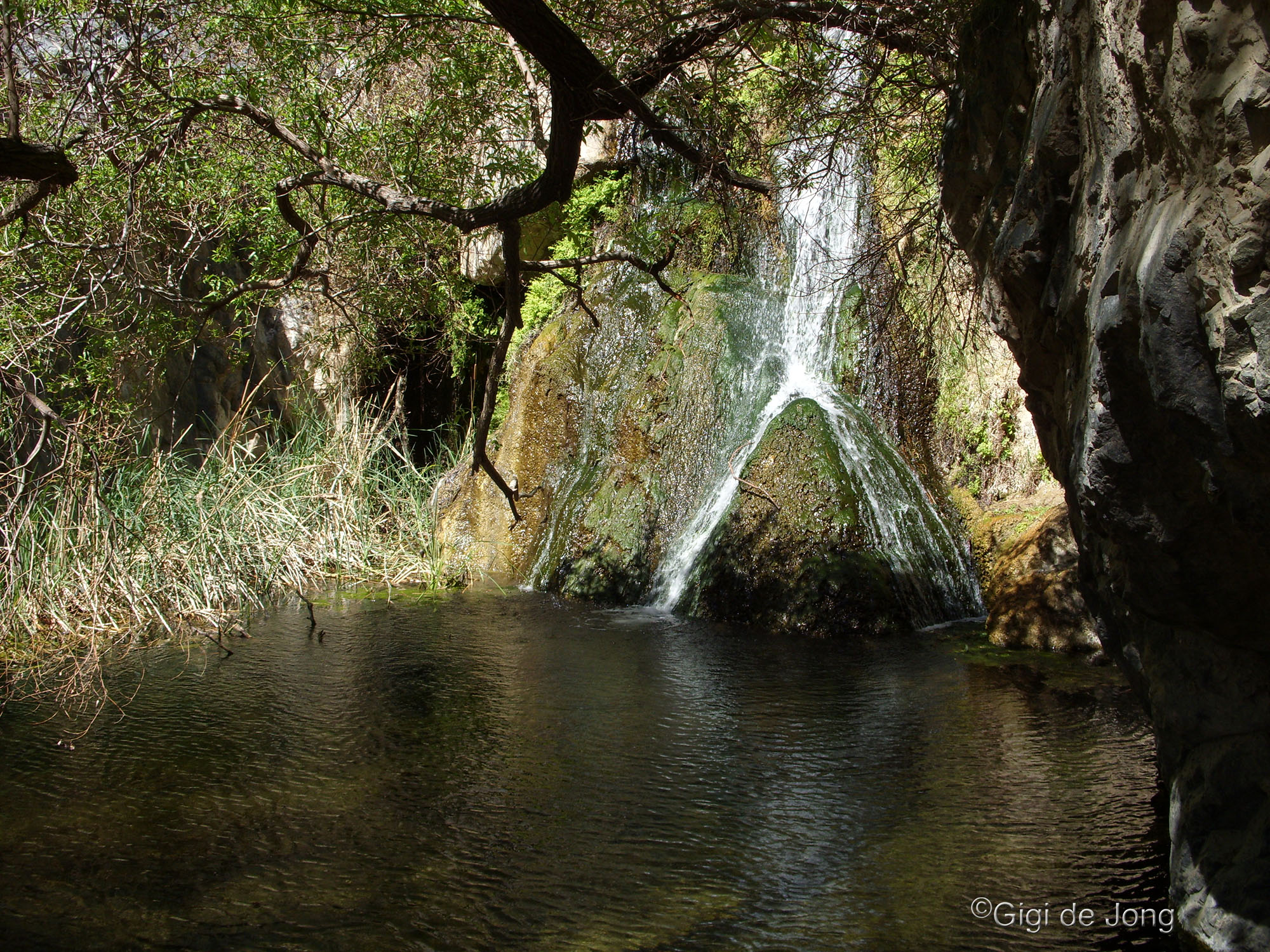
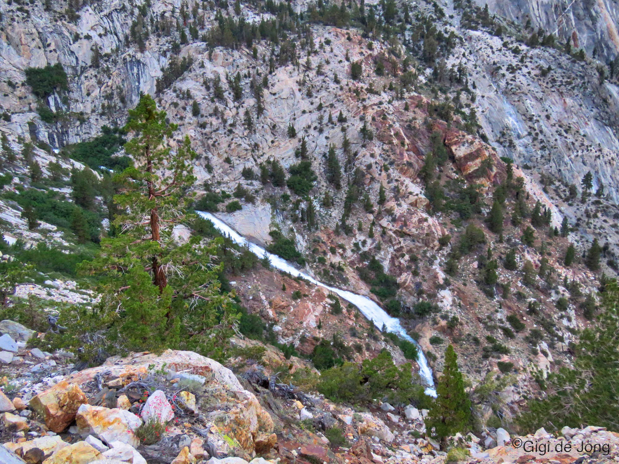
Cardinal Mine Falls : Bishop Creek, Bishop
![]() Roadside View
Roadside View
Cardinal Village Resort and the old Cardinal Mine site are located 17-miles from Bishop along US-168 W. on the road up to Lake Sabrina. This waterfall cascades down a narrow chute from the hanging valley above, in which North Lake sits. It falls into the deep valley below, where the village and mine are located, then cuts down the canyon into Bishop. The long view of this cascade is seen from the roadside turnout across and well above the valley below. It’s a stunning vista of canyons and crags, and forests and streams.
The cascade is fullest in spring when the winter snow melt runs into North Lake and high over the rim into this chute. It is perennial and some summers the flow remains strong. The falls might be best in autumn, when the aspen groves in the valley below are changing color. In winter this road is plowed up to the village of Aspendell and on a sunny winter day the icy falls will sparkle from this vantage point.
back to map
Cardinal Mine Falls : Bishop Creek, Bishop
![]() Hike
Hike
To get a close up look at this waterfall drive right into the Cardinal Village Resort area and find a parking spot. Pop into the resort and ask for the ‘secret map’ to the mine and learn about the history of Cardinal Mine and this lovely canyon. The resort is a great spot for coffee, breakfast, lunch, and on summer weekend nights the all-you-can-eat wood fired pizza is a popular outing. The latter is by reservation only and fills up well in advance. So, if you know when you’ll be visiting make sure to call and book.
To get to the falls on foot, follow the trail from the other end (south) of the resort toward the old mine site. The map below shows where the trail branches off to the waterfall. It’s not long, but it will require a bit of rock scrambling to get close to the cascade. One way the trail is a little over half a mile with about 250 feet of elevation gain.
back to map
Cardinal Mine Falls roadside view. Photo: Gigi de Jong

Cardinal Mine Falls up close. Photo: Gigi de Jong

Cardinal Mine Falls route map and elevation profile. Click here to download PDF.
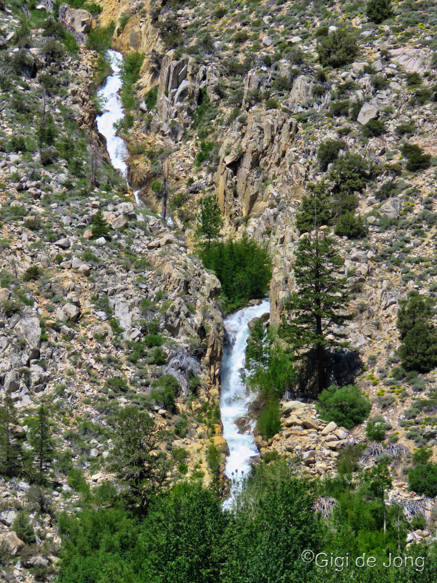
Piute Lake Waterfalls. Photo: Roberta McIntosh

Piute Lake Waterfalls map and elevation profile. Click on image to download PDF.
Piute Lake Trail Falls : North Fork Bishop Creek, Bishop
![]() Hike
Hike
This is probably the most strenuous hike, with falls at the highest elevation, included on this list. The hike begins at North Lake, which may just be one of the most beautiful high Sierra lake scenes that can be accessed by car – especially during fall colors season. Take the short drive on a combination paved and dirt road north off US-168 W. just above Cardinal Village. Day visitor parking is near the lake and pack station, and the trailhead begins in the campground. If you camp in the North Lake campground you could shave about 1,000 feet off the total length of the trail, but given that this is an 8-mile out and return roundtrip, that won’t make much difference. It’s also the trail with the most elevation change and you’ll climb about 2,000 feet in less than 4-miles.
The water that falls and cascades down from Piute Lake over a series of natural rocky dams is ever-changing. The strength of the flow and size of the falls are dependent on the winter snowpack. This will not be the largest falls, but the hike and setting will be the most serenely beautiful.
Caution: This trail begins at over 9,250 feet above sea level and rises to almost 11,000 feet at Piute Lake. For hikers unaccustomed to altitude this hike could induce altitude sickness. If anyone in your group complains of a headache, dizziness, nausea or appears to be disoriented leave the area immediately and return to a lower elevation. The symptoms should ease significantly within a short period of time, but if symptoms persist, head to the Emergency Room at the Northern Inyo Hospital.
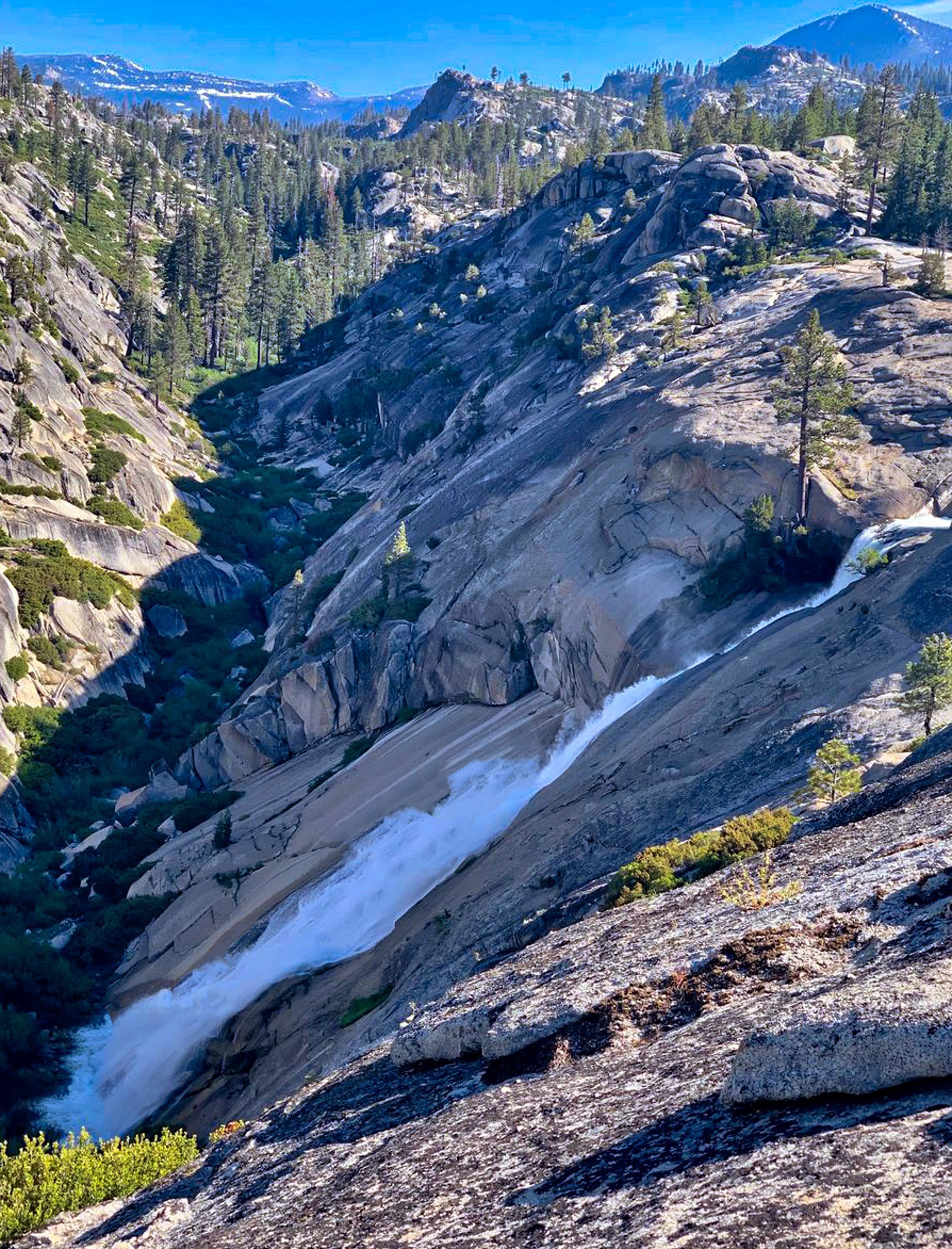
Sabrina Lake Waterfall : Bishop Creek, Bishop
![]() Hike or Kayak
Hike or Kayak
At the terminus of US Highway 168 W. at Lake Sabrina you will find yourself at just over 9,000 feet above sea level on the shores of a beautiful lake surrounded by alpine forest and craggy peaks that rise to over 11,000 ft. The hike to the falls that rush into the lake down the steep canyon cut by the Middle Fork of Bishop Creek is not far, but not easy. In fact, the final approach at the south-western end of the lake may be impassable if the lake is high and creek is full. In that case, the best way to get there is by kayak.
Kayaks and life vests can be rented at the Lake Sabrina Boat Landing and Café. On a calm summer day, it’s an easy out and back paddle. On the opposite shore, pull the boat up on the sandy beach to the left (south) of the incoming creek and hike the last, steep section to a rocky outcrop that overlooks this rather large waterfall. On your return to the boat landing stop in at the café and treat yourself to their homemade pie and ice cream.
back to map
Sabrina Lake Waterfall – Photo: Gigi de Jong

Lake Sabrina Falls map and elevation profile. Click on image to download PDF.
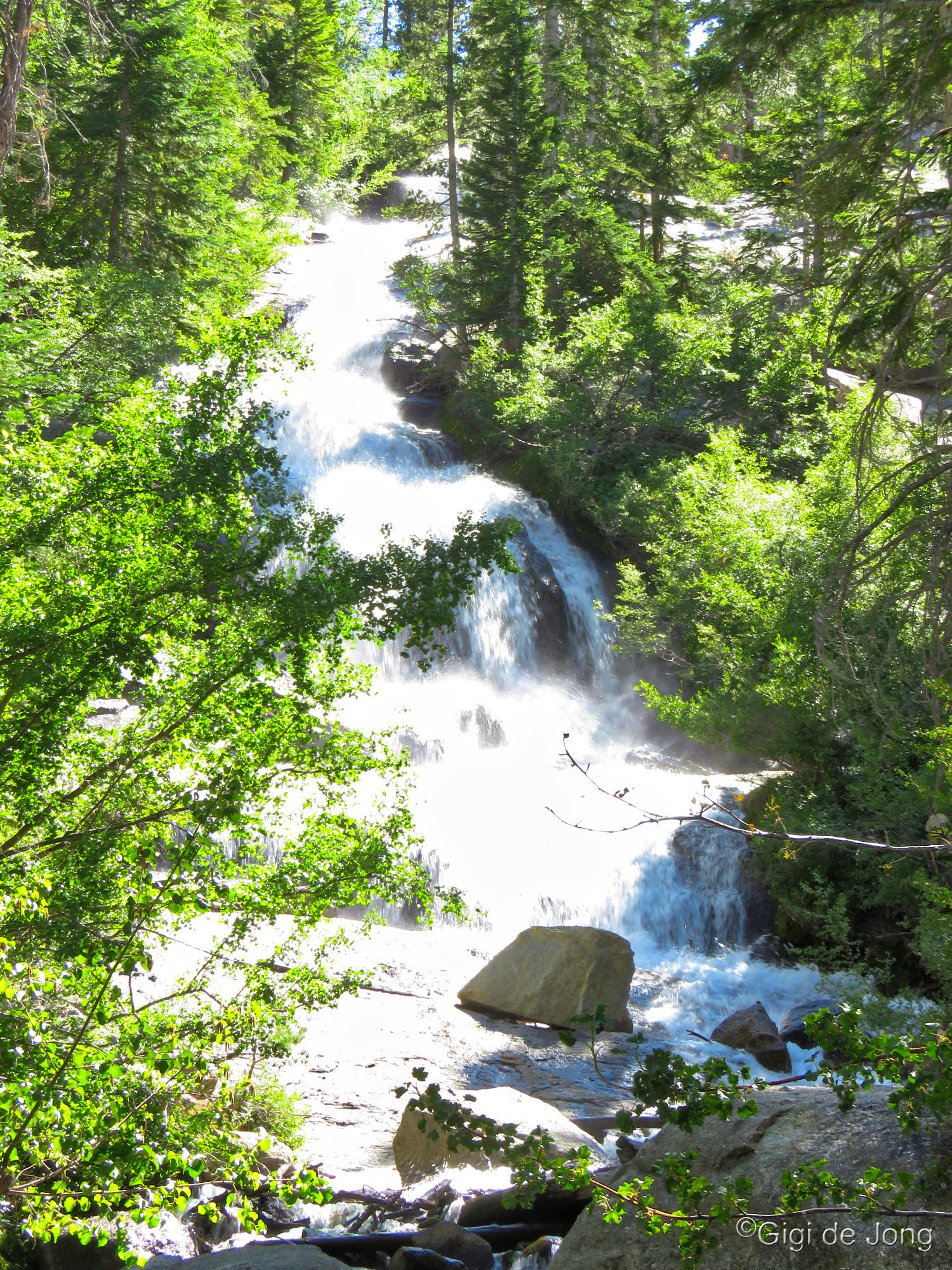
Pine Creek Waterfall. Photo: Gigi de Jong

Pine Creek Falls map and elevation profile. Click on image to download PDF.
Pine Creek Waterfall : Pine Creek, Bishop
![]() Hike
Hike
Pine Creek canyon is considered to be the next best example of a deep glacial canyon after Yosemite. It is a deep, rock scoured canyon with a large U-shaped cirque at the head of the canyon. The sides are bounded by high, steep walls and the mouth is bordered by glacial moraines. A drive up this canyon, on Pine Creek Rd., is an adventure in itself. It’s also a fabulous road bike ride.
From Bishop head north on US-395 for 10.3-miles to the junction of Pine Creek Rd. Turn left and follow the road for 9.5-mies to its end at the Pine Creek Trailhead. The trail begins just beyond the pack station. Walk through the gateway, pass by the homestead and mule pens, about 125 feet, to the trail entrance. This hike is fairly strenuous and the round-trip length is just over 4 miles.
The trail winds through a deep forest, then proceeds up the rocky mountainside for many miles and ultimately to Upper Pine Lake where the falls originate. The trail also eventually connects to the John Muir Trail. An excellent viewpoint for the falls, which is visible from across the canyon that it is etching into the mountain, is just over 2-miles along. Depending on the year and time of year, you many encounter a couple of smaller falls along the trail. In early spring a cascade from snow melt above the trail may impede your path as it thunders across the trail at mile 1.6. In summer and autumn the melt should be light enough to rock hop or wade across or it may be entirely dry.
Minaret Falls : Minaret Creek, Mammoth Lakes
![]() Roadside View
Roadside View
West of the town of Mammoth Lakes and beyond the famed ski resort is a deep canyon cut through by the Middle Fork of the San Joaquin river. The valley is known for numerous incredible sights and two of the world’s most famous trails, the Pacific Crest Trail and the John Muir Trail, pass through here. The towering Minarets, the iconic features of this town that can be seen from miles away, are most majestic from the Minaret Vista. It’s a sweeping view of the massive backcountry to the west and down to the valley below. The large waterfalls and cascades that flow into the valley from numerous creeks are barely seen as the scale of this vista is supremely impressive.
A good roadside view of the Minaret Falls is in the heart of the valley from the Minaret Falls campground. Access to the campground in a private vehicle is only possible when camping here during the summer months, mid-June through Labor Day. During this period day-trippers must take the Reds Meadow/Devils Postpile shuttle bus into the valley from Mammoth Mountain Adventure Center.
Many lovely falls, the most popular of which is Rainbow Falls (see more below), can be viewed during a day outing. A short walk from the visitor center to the Devils Postpile National Monument, a geologic wonder, should not be missed.
Minaret Falls : Minaret Creek, Mammoth Lakes
![]() Hike
Hike
Once you’re down in the Reds Meadow / Devils Postpile area this is an excellent moderate hike of just under 3-miles roundtrip. It does have some elevation gain and loss in each direction, so hikers should be prepared with snacks, water, layers, sunscreen and good hiking shoes. The hike begins at the visitor center and skirts around the Soda Lake and crosses the San Joaquin river. At a half-mile it joins up with the Pacific Crest Trail and heads to the falls viewpoint one-mile further. This is your chance to say you’ve hiked a portion of the Pacific Crest Trail!

Minaret Falls map and elevation profile. Click on image to download PDF.
Rainbow Falls : Middle Fork San Joaquin River, Mammoth Lakes
![]() Hike
Hike
This short and relatively easy hike to the lower falls serves up the pièce de résistance of this remarkable valley. The hike begins at the end of Minaret Summit Rd. in Reds Meadow Campground. From here it’s almost exactly one mile to the falls and just over 200 feet of elevation loss – so, it’s easy out and moderate back.
Add a little more adventure to this hike and begin at the visitor center and walk to the Devils Postpile National Monument first. Spend a little time there contemplating the marvels of nature, then hike on to Rainbow Falls from there. The out and back hike from the visitor center, via Devils Postpile, will add up to 5-miles roundtrip and a little over 600 feet of cumulative elevation gain and loss. You could rack up a few more miles and continue on to the upper falls, which would add further 2-miles and 400 feet.
All-in-all this would be the trifecta of attractions in the region.
back to map
Crater Creek Falls : Crater Creek, Mammoth Lakes
![]() Hike
Hike
If hiking is the objective and waterfalls are the reward, this could be a super choice for experienced, adventurous souls or groups. The hike begins at the Rainbow Falls trailhead and passes by the lower Rainbow Falls before heading down canyon along the trail designated as Fish Creek trail. It parallels the San Joaquin which cuts into the landscape below as granite ridges rise to create deep, narrow canyons. The trail flows alternately through the forest and out onto massive granite blocks. Crater Creek begins east of this valley near the south side of Mammoth Mountain. On its way to the San Joaquin, the waters of Crater Creek plunge over the massive granite benches that delineate these canyons. The view of this falls is from the brink of the drop and just off to the side. Both views provide a grand view of it plummeting over a near vertical cliff. Be extra careful of sand, water, or ice on the granite as a slip here could have very serious consequences.
The roundtrip hike is just under 9-miles with a little over 3,000 feet of cumulative elevation gain and loss. It’s a big day … and it’s a big falls!
Crater Creek Falls.

Crater Creek map and elevation profile. Click on image to download PDF.

Horsetail Falls. Photo: Gigi de Jong

Horsetail Falls map and elevation profile. Click on image to download PDF.
Horsetail Falls : Rush Creek, June Lakes
![]() Roadside View
Roadside View
The June Lake loop drive is another spectacular auto tour in the region! Head north from Bishop on US Highway 395 for 53-miles and turn left onto CA-158 S. at June Lake Junction. This loop road hugs the base of a horseshoe shaped canyon for 16 miles and winds through the town of June Lake, past the June Mountain ski resort, and four lovely lakes, all of which offer great adventure and experiences for visitors. The loop deposits you back onto US-395 6-miles north of June Lake Junction.
About half way around the loop, near Silver Lake, is a roadside pullout where Horsetail Falls can be seen high above the canyon floor. It is the biggest falls in June Lake with a drop of almost 300 feet where Rush Creek flows down from Agnew Lake above. In spring, when the flow is high, it’s easy to see why it’s named Horsetail Falls. When the flow is low it’s not much to look at from this vantage point, but the hike up will provide an altogether more amazing view of this falls and the surrounding countryside.
Horsetail Falls : Rush Creek, June Lake
![]() Hike
Hike
The hike to the falls and the Horsetail Falls overlook begins beyond Silver Lake at the day use parking area opposite Silver Lake Campground. The trailhead is indicated as Gem Lake trail as it climbs well beyond the falls and Agnew Lake to Gem Lake.
Horsetail Falls is a significant indicator of water resources in the Eastern Sierra and of significant historical interest. It is a controlled flow from the Rush Creek Hydroelectric project that encompasses three dams in the high Sierra; Agnew Lake Dam, Gem Lake Dam, and Rush Meadow Dam which impounds Waugh Lake. Construction of these dams was done in 1915–1918, followed by alterations and additions in 1924-1925. Significant improvements and repairs have been done almost every decade since.
According to documentation from the Library of Congress, “The district is significant under National Register of Historic Places Criterion A (broad patterns of history) and Criterion C (distinctive characteristics of period and type of engineering and construction that represent the work of a master). The Period of Significance for the district is 1915-1925.”
Hiking up to the falls and lakes beyond is short, sweet, and steep. The trail provides very little shade, which means it also has unobstructed views in all directions. Along the way the trail crosses and flanks an incline railroad, the Agnew Tram, which is controlled by the Southern California Edison Company. Hikers should take care when crossing and never walk on the tramway.
The head of Horsetail Falls is about 2,000 feet downstream and 300 feet below Agnew Lake Dam, which impounds this naturally occurring glacial lake. The dam abuts the high granite walls behind this remarkable horseshoe canyon. If you’re feeling very energetic hike up and beyond the dams for a closer look at these marvelous feats of engineering and some insight into the history of water in the region.
Lee Vining Falls : Lee Vining Creek, Lee Vining
![]() Hike
Hike
Just south of the town of Lee Vining, 64 miles north of Bishop on US-395, is the junction of CA-120 W., Tioga Rd., to Yosemite. In winter Tioga Rd. is closed and buried under deep snow from very near the intersection. The closure takes effect a few miles into Lee Vining Creek canyon just beyond the junction of Poole Power Plant Rd., which provides year-round access to the facility. More exciting for climbers and visitors to the area though, is that it provides access to one of California’s premier ice climbing venues.
It’s a fascinating drive into the this very deep, steep sided canyon. Some of the ice falls can be seen from the parking area. Hiking in and climbing the ice falls is only recommended if you are an experienced ice climber and have all the right gear. However, beginners can sign up for courses and guided climbs with either of Bishop’s leading mountaineering schools and guide services, Sierra Mountain Guides, or Sierra Mountain Center. Introductory lessons usually begin at an icy Horsetail Falls in June Lake and then progresses to the bigger, better Lee Vining Ice Falls.
Contact the folks at the above guide services or check out the seasonal Eastern Sierra ice report to find out more about ice climbing conditions in the Eastern Sierra.

Lundy Canyon Lower Falls map and elevation profile. Click on image to download PDF.
Lundy Canyon Lower Falls : Mill Creek, Mono Lake
![]() Hike
Hike
Within Lundy Canyon a series of falls drops down Mill Creek as the water makes its way to Mono Lake, 70-miles north of Bishop. Lundy Lake Rd., heads west off US-395 just beyond Mono Lake at the intersection of CA-167, Pole Line Rd. Drive this good paved road to its terminus at the Lundy Canyon trailhead where a turnaround offers a number of shaded parking spaces alongside Mill Creek. The hike to the lower falls is a short and relatively easy hike of just over ½-mile and about 300 feet of elevation gain one way. Wildflowers are usually extensive and beautiful here in late summer. Lundy Canyon is also well-known for fall colors.

Lundy Canyon Upper Fall map and elevation profile. Click on image to download PDF.
Lundy Canyon Upper Falls : Mill Creek, Mono Lake
![]() Hike
Hike
Beyond the lower falls, the trail will climb alongside the creek gradually for about 1.5-miles. A long cascade can be seen intermittently for most of this section. The trail then climbs steeply onto a crest above a deep ravine, where a chute produces a stepped, latticework waterfall of about 300 feet. The total trip from the trailhead to the upper falls and back is 5-miles with a total cumulative elevation gain and loss of a little over 4,000 feet.
Last Words on Waterfalls
Please use caution when hiking in the Sierra Nevada, any time of year, and especially near water and waterfalls. Always tell someone where you are going and when you expect to be back. Cell phone reception is limited or non-existent in many of the places described above. Study the maps, download GPS tracks, and take paper maps as a backup. Pack layers for sudden changes in weather, extra food or plenty of snacks, take plenty of water or a water filter, and carry a flashlight or headlamp. When hiking, please always stay on trails where designated and do not cut switchbacks. If some cross-country is necessary (hiking where no trail exists) please don’t crush the brush.
Please note that ALL waterfalls in the region, even if termed perennial, can be very low or even dry if the preceding winter has had significantly low snowfall. Conversely any wash, canyon, or rivulet can produce a fast-flowing cascade or waterfall if the previous winter has had good or higher than average snowfall. If you hike into the backcountry in early spring do not cross ice bridges over creeks or falls. Note too, that water follows the path of least resistance and sometimes a designated trail becomes a temporary stream.
Always be bear aware!
#VISITBISHOP GUEST EXPERIENCES
**Make sure to tag your Instagram and Facebook photos with #VISITBISHOP so we can find them!!