Cycling in the Eastern Sierra
We believe there is no other place on earth that offers as much opportunity for year-round road cycling as the Eastern Sierra. It is one of the most topographically diverse and beautiful landscapes in our country. It is also one of the most photographed regions in the US.
Situated on the east side of the Sierra Nevada mountain range the Eastern Sierra appears, to the uninitiated eye, to be a place where time has stood still. There is one main highway, US 395, which cuts through vast plains of uncultivated lands that appear to have had little human interference. The towns are small, few and far between.
Miles and miles of beautiful biking roads
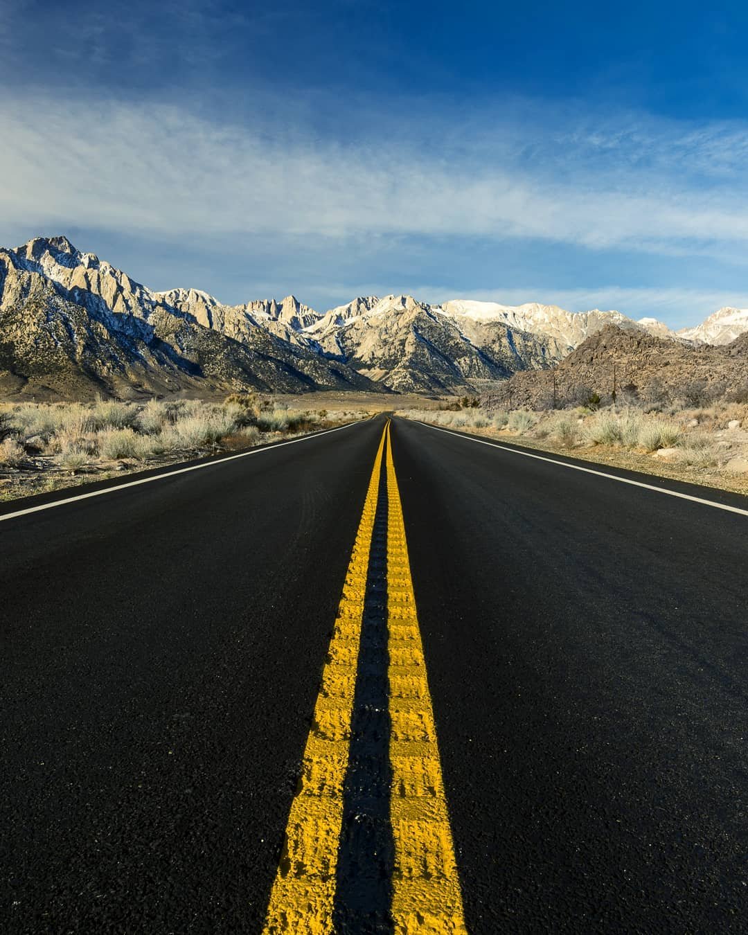
Our paved roads are lightly trafficked and a road cyclist can ride for many, many miles without encountering a traffic light or a stop sign.
The region comprises two counties, Inyo and Mono, and covers a distance of about 250 miles south to north. Inyo County (the second largest county by area in California) and its northern neighbor, Mono County, are two of the least populated counties in California. Together these two counties cover a little under 10% of the total land area of all of California, with a staggering 99% of land in Inyo County and 93.6% of Mono County designated as public lands.
Inyo County is home to the lowest and highest points in the contiguous United States. The lowest point, Badwater Basin in Death Valley National Park, sits at 282 feet below sea level and a mere 85 miles west (as the crow flies) is the highest point, Mt. Whitney, at 14,505 feet above sea level. It’s a topographical marvel.
Hundreds of miles of maintained paved road are rideable – from the low elevations in Death Valley National Park in the south, to the high elevations at the gateway to Yosemite Valley in the north.
In the center of the region is the amazing Owens Valley. Geographically speaking it can be described roughly as being 100 miles long by 5 to 20 miles wide. The valley floor sits at about 4,000 feet above sea level (ASL) and is flanked by the Sierra Nevada to the west and the White and Inyo Mountains to the east. The mountains rise suddenly and dramatically on both sides with peaks reaching over 14,000 feet above sea level. The Owens Valley is considered one of the deepest valleys in the United States.
Cycle these magnificent mountain roads up to incredible destinations such as: Onion Valley, Glacier Lodge, Bishop Creek Canyon home to Lake Sabrina and South Lake, Pine Creek Canyon, Upper and Lower Rock Creek, and the Ancient Bristlecone Pine Forest all near or above 10,000 feet above sea level.
Bishop is the heart of the Eastern Sierra. There’s a ton of fun riding to be done right here in our big backyard. With rides ranging from super easy and leisurely, to highly technical and challenging (and everything in between) there’s a road here for you.
Getting great rides requires a bit of planning. Our big backyard is huge and seasonal changes present different opportunities for various types of cycling. It’s important to know when and where to go to have the best rides each season. We suggest you study the information below and choose the biking adventures that best suit you, your family, and friends. You can choose as many adventures you like; find favorites and discover challenges.
Bishop and the Owens Valley have about a 92% chance of dry days, which means that there are about 335 sunny days a year for great cycling adventures in the Eastern Sierra. Just to be sure, call us at (760) 873-8405 or stop in at the Bishop Visitor Center at 690 N. Main Street in Bishop to check on current weather and road conditions.
Be prepared! ALWAYS tell someone where you are going and when you expect to be back. Many places in our beautiful big backyard don’t have cellphone signal. Dress in layers, have a basic bike repair kit, and pack a small headlamp. Wear sunscreen, even in winter. Carry plenty of water and energy rich snacks.
Choose your ride. Choose your adventure.
Caltrans District 9 Bicycling Guide (arcgis.com)
Want to go big? Check out this BikePacking overnight loop that highlights the complex environmental, geological, and political history of California’s Owens River Valley. Route landmarks include the Eastern Sierra foothills, Manzanar War Relocation Camp, Alabama Hills, Owens River watershed, and Inyo Mountains…
Everything You Need for the Best Road Cycling Experiences
Click on each toggle bar below for details on what, where, how, why and more.
What & Who
Road cycling is still one of the most popular ways to cycle. In almost every community around the world, it’s a method of commuting to and from work or school, it’s done as a form of exercise for physical and mental health, and it is also a highly competitive multi-disciplinary sport. It’s also a great mode of travel for a touring vacation and, for many around the world, it’s become a nomadic lifestyle.

Biking is for everyone.
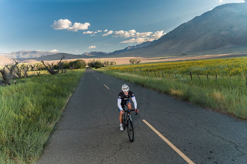
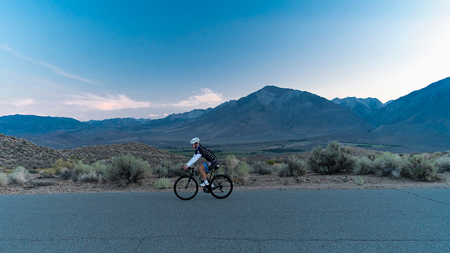
One of the most important aspects of road cycling anywhere … is safety. Our Eastern Sierra paved roads are remarkably safe, some with good wide shoulders, and others with such light vehicle traffic use that a road cyclist can ride for hours and miles without seeing more than just a handful of cars.
Come ride for fun, for exercise, or for training and enjoy the benefits of clean air, wide open spaces with huge vistas, small communities with excellent amenities, and a host of other fun activities.
Our guests tell us that they visit often because each season offers something different and exciting to explore each time. And we know that many pro riders train in our big backyard so that they can get the benefit of high-altitude acclimatization, quiet roads, fantastic hill climbs and descents, and friendly hospitality in our welcoming western town.
Where & When
Bishop is situated pretty much smack-dab in the middle of the Eastern Sierra – by distance, by elevation, and by time.
A highway to heaven? Photo: @oscarguzman
The region comprises the two counties, Inyo and Mono, and covers a distance of about 250 miles south to north. There is one main highway, US 395, that runs through the region with Bishop located just about halfway. Near the south-eastern end of the region, Death Valley sits at and below sea level, and most of the western side of our region rises to well over 10,000 feet along the Sierra Nevada mountain range. Bishop is nestled at about 4,150 feet between this enormous range and another giant to the east, the White and Inyo Mountains, which also rises to over 10,000 feet. Bishop is almost in the center of this elevation profile. The time it takes to drive from Furnace Creek, the tourism hub of Death Valley, to Bishop is a little under 3-hours. Onward and upward to the northern end of region, which ends at the Mono County and California state line, is a drive of about 2½ hours. So, this puts Bishop about halfway on the timescale.
There you have it. Bishop is the most perfectly placed mid-point for year-round cycling adventures in the Eastern Sierra.
When winter is cold and snowy in the upper elevations – we ride in our cool, high-desert big backyard or head lower down to where it’s even warmer. In summer when our low- and mid-elevations are hot and sultry – we ride at higher elevations and in the mountains where it’s cool and refreshing. Spring and fall are delightfully unpredictable and always stunningly beautiful. Keep tabs on the local weather and road conditions to know where to ride on any given day.
Not everything is available all year, but each season has something special to offer. It is important to plan your ride.
How & Why
Bishop, the Owens Valley, and nearby areas provide extensive opportunity for casual road riding and serious training for competition cyclist. As you plan your visit review the maps and list of potential routes, seasonal accessibility, and ride rating.
We’ve created four categories and given each route a classification in each category. Plus, we’ve written up short descriptions of each to give you an idea of what to expect. you can make an informed choice and get a great ride whenever you are in the Eastern Sierra.
Region: South. Central. North.
![]()

![]()
Elevation: Low. Mid. High. Variable.


Season: Spring. Summer. Fall. Winter.


Rating: Easy. Moderate. Strenuous. Expert.


Note that some of the routes are loops, which means you’ll start and end where you park your car. Many are out and back, some with significant elevation gain and loss, and, depending on your skill and fitness level, you could ride back to your vehicle. Some may warrant or require a shuttle depending on your goal and/or ability. Make sure you know what to expect, what you can accomplish, and make a plan with a friend or family member if you need a pickup.
We have a great local transit service, Eastern Sierra Transit (ESTA), that provides bus transport between Bishop and Mammoth Lakes (and beyond) all year. Buses are equipped with bicycle racks making this a great way to get a shuttle from town to town.
Links & Things
There are some fantastic cycling events and challenges in the Eastern Sierra and we have great retailers and rentals to get you on the road and out in the hills. Take a look at these links.
Clubs. Events. Challenges.
- Eastside Velo
- Everest Challenge
- Graniteman
- June Lake Triathlon
- L2H Challenge (Lowest to Highest – Badwater to Whitney Portal)
- Mammoth Gran Fondo
- Mammoth Tuff
Bike Shops & Rentals
Plus, there is a wealth of information about cycling online and here are some links if you’re really keen to geek out about biking.
Road Biking Location Map
Each bike icon indicates the location of a road bike ride. Scroll down for route descriptions, ratings, and simple route maps with elevation profiles.

Round Valley
Pleasant Valley loop


Length: 19.3-miles
This is a ride that has a little of everything in just the right measure. It has some short uphills and downhills, sharp corners and sweeping bends. You’ll work hard enough to stay warm, but not so hard that you can’t lift your head and admire the awe-inspiring views. The route follows quiet country lanes and a pleasant, car free ride along the shores of the Pleasant Valley Reservoir.
Our route guide starts and ends at the Millpond Recreation Area, about 7 miles west of Bishop just off US Highway 395, on Sawmill Rd. There is plenty of parking and amenities include restrooms, picnic area, and a playground. It’s a perfect starting point especially if you’re with a group and not all are cyclists.
There are a number of good points along the route where you can park a car safely to ride this loop. Other start/end points are at Pine Creek Rd junction with Highway 395, Gorge Rd & Old Sherwin Grade junction (just off Highway 395), or the Pleasant Valley Dam parking area. It really is a pleasant ride!
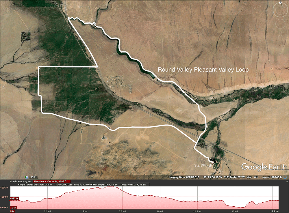
Round Valley Pleasant Valley Loop map & profile

Car-free ride along the shores of Pleasant Valley Reservoir
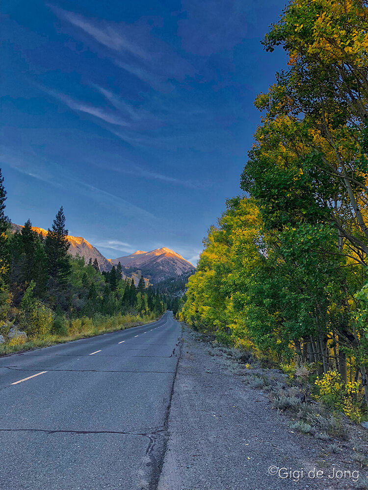
Pine Creek Canyon
Length: 18 miles


For some this may be a warm-up and for others this could be a fairly strenuous workout. Park in the clearing at the junction of Pine Creek Rd and US 395, 10-miles north of Bishop. The road begins with an almost imperceptible climb for the first 1-mile then increases steadily for the next 8-miles to the terminus at the head of Pine Creek Canyon. At 3-miles along it passes alongside the settlement of Pine Creek Village (formerly known as Rovana) where the old, quaint homes were once part of a large mining operation that has long since been abandoned.
As the road climbs the next 6-miles up into this deep, glacial canyon it twists and turns and fluctuates between 4% – 11% grade. The steeper grades are not sustained for too long making this a really great ride any time of year. Conditions in mid-summer and mid-winter could be challenging – with high temps at the start point during summer and snow on the road during winter – but not impossible for the hardy cyclists. Fall and spring are spectacular for this ride.
This route can be extended by starting in Bishop and riding out the back roads past Millpond Recreation Area and through the lovely Round Valley.

Old Sherwin Grade &
Lower Rock Creek
Length: 18.6 miles
The Old Sherwin Grade Rd is a well-maintained paved road that follows some of the historic old wagon road that dates back to 1870, built by James L.C. Sherwin. It more-or-less parallels the current US 395 that takes motorists only 10 minutes to achieve a distance and elevation gain that once took wagon trains an entire day.
Today the Old Sherwin Grade Rd is used primarily by local traffic to reach the small settlements of Paradise and Swall Meadows, auto tourists on leisurely sightseeing drives, and cyclists who ride this sinuous road with its sweeping views of this impressive landscape with Wheeler Crest to the west, and the White Mountains to the east.
After about 3-miles of low lying, flatland the road begins a slow and steady climb up onto this escarpment where it weaves around the contours of this sparsely vegetated high desert. It is exposed and sometimes windy, but wonderfully refreshing in the right season. It’s ridable all year, with the caveat that a blistering summer day can be all but unbearable at the lower elevations and a cold winter day could be more than challenging at the higher elevations.
Our route map shows a turnaround at Sherwin Summit, just beyond Swall Meadows Rd, at a cutting where the road drops down into Lower Rock Creek. The ride can be extended 7‑miles, by a further 3.5-miles along Lower Rock Creek road and 3.5-miles back. This section has a short, steep drop down to the creek and then a steady climb for almost 3-miles up to the intersection with US 395 near Toms Place. Lower Rock Creek alone is a short, fun, and somewhat strenuous ride that can be done as out-and-back from here, Sherwin Summit, or from the Lower Rock Creek trailhead parking pullout.
Cyclist on Old Sherwin Grade

Old Sherwin Grade map & profile

Lower Rock Creek map & profile
Bishop Creek Canyon
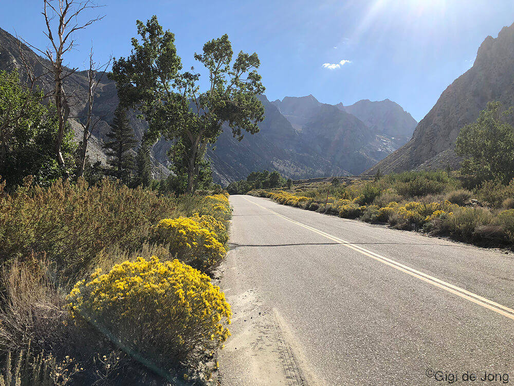
Bishop Creek Canyon offers many options for road cycling up to and between the lakes in this high elevation canyon. Even though the canyon is popular with locals and visitors, the road is never too busy for a safe and beautiful ride on a good day. The upper sections of the canyon, from the village of Aspendell, are closed in winter and usually under a heavy snowpack. Although open, the road is often icy from about 6,000-feet in a heavy snow year. Late spring to early fall is magical in this canyon.
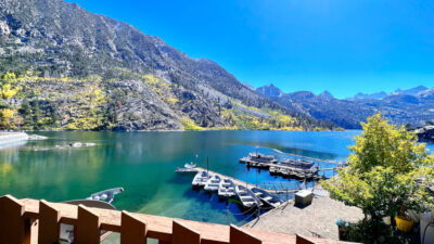
View of Lake Sabrina from the cafe deck. Photo: Gigi de Jong
The upper elevations of the canyon are a perfect escape from the heat of summer and the lower portions are a wonderful way to keep moving and warm in winter. Always be on the lookout for animals and pedestrians – especially in the evenings and during leaf peeping season.
Always dress in layers with even more than you think you’ll need. The elevation change here has a huge effect on the temperature and the mountainous terrain can create its own micro-climate, resulting in sudden rainstorms – especially in summer. Large cumulus clouds building over the mountains well before noon are reliable indicators of late afternoon thunderstorms. Clear, sunny days, which are the norm, may produce fluffy, late afternoon clouds and these usually end in dry, gloriously colorful sunsets.
Call (760) 873-8405 or come into the Bishop Visitor Center at 690 N. Main Street, to discuss current weather conditions just to be sure.
back to hotspot map
West Bishop to Lake Sabrina

Length: 32.7 miles
The full ride from west Bishop to the lakes at the top of Bishop Creek Canyon is for best done by advanced riders. Begin at Izaak Walton Park, 3600 W. Line St., West Bishop, on SR 168 West heading out of town. There’s safe parking adjacent to the park, with a small public restroom, and a lovely spot to end a hard ride on cool, green grass under tall, shady trees alongside the burbling Bishop Creek.
The ride starts with a gentle climb for the first 2-miles, then it serves up an incline that averages 5.5% grade with some sections verging on 10.5% over 14.5-miles ending at Lake Sabrina at an elevation of just over 9,800 feet. The Boat Landing café serves cold beer, hot coffee and tea, burgers, and homemade pie and ice cream during the summer months. Public restrooms are available by the parking area.
During mid-summer a good alternative starting point is at the junction of Buttermilk Rd, some 5-miles further and 1,000 feet higher up, where safe parking is available just off the roadway.


West Bishop to South Lake
Length: 39 miles
Start this ride as per the above, but at mile 12.5 lookout for a left turn onto South Lake Rd. The road dips down a few hundred feet then continues to climb up the south fork of Bishop Creek to South Lake at almost 10,000 feet elevation. Vault toilets are available at the South Lake parking area and trailhead. Pack your own snacks and water to sustain you on this ride.
South Lake road. Late afternoon early fall.

Bishop Creek Canyon to South Lake map & profile
South Lake to Lake Sabrina
Length: 11 miles
A wonderful alternative to the two big rides described above, from the valley floor to these two lakes, is to cycle from one to the other. This is one of the best summer rides in the area. The air is cool, the trees are green, the sky almost always bright and blue, and it can be done solo. Get a great 22-mile ride going out and back – either direction – or arrange a shuttle for a one-way ride.

Near South Lake

South Lake to Lake Sabrina map & profile
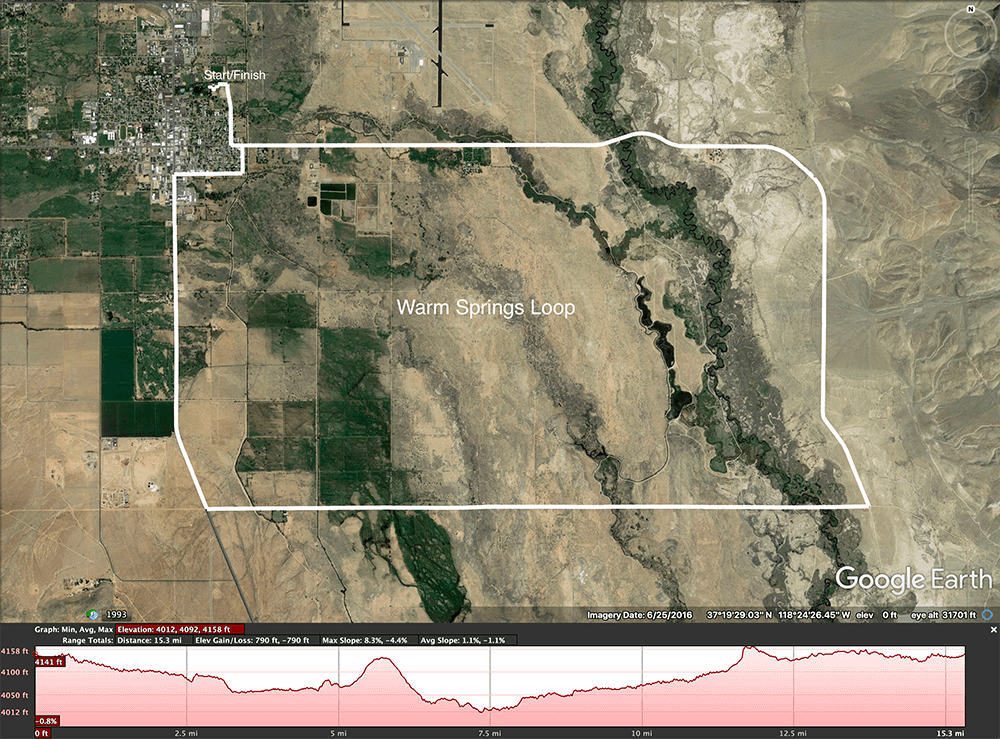
Warm Springs Loop
Length: 15.3 miles
A good start and end point for this ride is from the east side of Bishop City Park where there’s ample parking. The park offers numerous amenities and things for any non-cycling members of a group to do and keep kids entertained. Plus, there’s a great dog park for furry family members. Park on Spruce St. or the lot adjacent to the city park on Bruce St.
Begin the ride by following Hanby St. south to E. Line St. then turn left, and head east toward the White Mountains. At about mile 4.5 the road turns south and changes name to Eastside Rd. At mile 7 the route turns westerly onto Warm Springs Rd. The highest point of the ride is at the junction of US 395 where the route turns north to head back to town. In order to avoid the narrower, busier section of downtown take a right at Clark St. then, in a couple of blocks, turn left (there’s nowhere else to go) at 1st St., then do a quick left/right onto E. Line and Hanby St. to get back to the Bishop City Park.
This is an excellent loop with minimal elevation gain and loss – just 790ft. Ride it at an easy cadence for a relaxing and energizing outing, or push hard for an energetic workout. The views are marvelous as you roll across the river and ride along the base of the White Mountains where the vista out across the Owens Valley is wild and expansive.

Glacier Lodge Rd
Length: 21.2 miles
Fifteen miles south of Bishop is the town of Big Pine, which offers start and end points to a number of great hill climbs into the ranges to the west and east of the Owens Valley. This ride along Glacier Lodge Rd. up to the Big Pine Creek Trailhead is the easiest of the lot that originates here. But don’t let that fool you … it’s still a lofty ride gaining 3,821 feet in 10-miles. The average slope is almost 7% with the steepest being just over 12%.
Park at Mendenhall Park on Baker Creek Rd. just off US 395 on the north side of Big Pine. Here too there are restrooms, water, kids’ playground, and shade trees. Cycle north along Baker Creek Rd., turn left onto N. School St., then right onto Crocker Ave., which becomes Glacier Lodge Rd. a half-mile into the ride. Keep riding up the canyon until you reach the road’s end at the trailhead.
This a great place to stretch your legs and relax the mind before the ride back down. Take a cool, shady walk of less than 2,000 feet to the bridge over First Falls.


White and Inyo Mountains
At the junction of US 395 and SR 168 East, just north of Big Pine, is an information kiosk about the Ancient Bristlecone Pine Forest. This is great start point for a couple of impressive rides that go high and far into the White and Inyo Mountains on the eastern flank of the Owens Valley.

Ancient Bristlecone Pine Forest
State Route 168 E. weaves up into the White Mountains and summits at Westguard Pass 14-miles along. Just before the summit, at mile 12.7, White Mountain Rd. begins its ascent to the Ancient Bristlecone Pine Forest.
On the southern end of the range, about 2-miles along SR 168 E. from the starting point at US 395, is the junction with Death Valley Rd. This traces the northern end of Death Valley National Park and enters Eureka Valley where the pavement ends.
These epic rides are not just fantastic, low-traffic roads with incredible scenery, but they are also a close-up view to the ancient natural history of this region. Human-made relics of the past are also reminders of the more recent cultural history in the region.
back to hotspot map
Death Valley Rd to
Waucoba Saline Rd
Length: 31 miles
Park in the designated parking area just off US 395 at the Bristlecone Pine Information and Historic Landmark and begin riding east on SR 168. At mile 2.28 turn right onto Death Valley Rd. and begin a steady climb with an average grade of 4.5% (maxing at 9.3%) in just over 13 miles. Stop, breathe, rest, drink and eat some snacks at the junction with Waucoba Saline Rd. In all but mid-summer it can be much cooler up here. So bring layers, especially for the fast and fun ride down which can feel chilly at the top.

Made it to Waucoba Saline Rd junction!

Death Valley Rd to Waucoba Saline Rd map & profile
Death Valley Rd to
Eureka Valley
Length: 63.5 miles
This ride begins and follows the same route as the one above to Waucoba Saline Rd, then continues over the summit about a mile further to drop down through narrow canyons, across Joshua Flats, to an abrupt end at the northern end of Eureka Dunes.
Only the pavement ends here and the road continues as a wide, rough dirt road to the dunes. But, when on a road bike, this would be the place to stop and take in the spectacle of the grand landscape ahead.
Up to this point it has most likely been a beautiful and grueling 31.6 miles with over 4,000 feet of elevation gain and loss. The return will make the grand total a massive 8,290 ft of elevation gain and loss in 63.5-miles.

View from the pavement end in Eureka Valley

Death Valley Rd to Eureka Valley map & profile
White Mountain Rd
Length: 46 miles
This ride tops out at just over 10,000 feet above sea level. It is a sustained climb that makes the cumulative elevation gain of 6,880 feet just a little more than the actual elevation difference from bottom to top of 6,194 feet. So, not much down on the way up and not much up on the way down. Sounds like the perfect ride – for an expert rider.
But … rider beware! Altitude acclimatization may be very necessary before attempting the full ride. A great way to prepare for this is to ride some of the lower elevation climbs such as Old Sherwin Grade Rd., Pine Creek Rd., Glacier Lodge Rd., Death Valley Rd to Waucoba Saline Rd., then ride this route up to the junction of White Mountain Rd. and return.


Onion Valley Rd
Length: 26.6 miles
This is the ride that consistently ranks as the toughest climb in California. It’s even been ranked at #3 in the world in Bicycle Magazine. Besides being tough, it’s incredibly beautiful and, unlike many of the other tough rides around the world, there is very little vehicle traffic on it. Why would one want to ride anywhere else?
It originates in the central Owens Valley town of Independence, which is the county seat of Inyo County. Park on the south side Dehy park on N. Washington St. just off US 395. As with all the other lovely parks in our area, there are restrooms, playground equipment, green lawns, and shady trees for other family activities.

