Check these blogs for more great trail run info
Tungsten Loop
Rossi Hill
Lower Rock Creek
Must Do Runs
Chocolate Peak
Good. Better. Best.
See why Bishop is ranked as a top trail running town
Bishop, California is trail-running heaven. Welcome to our comprehensive trail running page. If you’re looking for new terrain and to get out into natural landscapes, you’ve come to the right place. Our big backyard is diverse and pristine. It offers a vast array of trail- and mountain-running options all year.
Time and again, studies show that contact with nature significantly improves our physical and mental health. Nature is good medicine! Research also shows that running is very beneficial to overall health and, according to an article in Runner’s World, “trail running is a much more intense total-body workout than road running.”
When it comes to trail running in a natural environment the benefits are greatly increased.
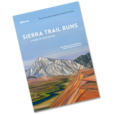
Click on the cover image below to order your Sierra Trail Runs guidebook.
Guests of our small community are awed by the size and diversity of the Eastern Sierra and often comment on the feelings of pleasure and satisfaction they have after taking time to enjoy our big backyard. Access to a huge variety of terrain from arid high desert surroundings to forested trails in high alpine meadows and granite wonderlands is often less than a 20-minute drive away.
Some areas are inaccessible or inhospitable in certain seasons. Winter delivers a deep snowpack to the higher elevations and summer brings soaring temperatures to the lower lying valley. The residents of our small community will tell you, “When it’s hot in summer we go high, when the snow is deep we go low.” Spring and fall are delightful almost everywhere.
From the wide-open terrain of the Owens River valley to the rocky outcrops of Buttermilk Country and the Tungsten Hills, from the jagged peaks of the Sierra Nevada to the west to rugged ridges of the White Mountains to the east there are trails for all abilities in all seasons.
Bishop was ranked #1 in Trail Runner Magazine’s Top Towns in 2016 and the site of their annual photo camp in 2018.
Jump to Trail Runs map below
Everything you need for a great trail running experience
Click on each toggle bar below for details on what, where, when, who, how, and why.
What & Where
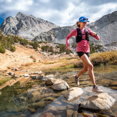
Trail running in the South Lake area of the Eastern Sierra Nevada, above Bishop, California on Bishop Pass. Photo: PatitucciPhoto
Trail running is booming worldwide. According to World Athletics, “Trail running has become one of the fastest growing sports in the world.” Local area trails in parks and green spaces in developed and urbanized areas are often overcrowded and may not provide enough diversity and stimulation. Our big backyard is huge.
It is close to some of the largest urban areas in California. Within a half day drive (just one tank of gas) guests can be in one of the most spectacular settings in California. Did you know it is one of the most photographed regions in the country? Come and see why.
The Eastern Sierra is remote, diverse, and pristine. It is a loosely defined area that lies east of, and encompassing, the crest of the massive Sierra Nevada mountain range. The region spans about 200 miles south to north and about 40 miles east to west and includes most of Inyo and Mono counties. It covers alpine mountains, sub-alpine foothills, riparian valleys, high desert scrubland, and some of the basin and range that makes up the Great Basin of the USA.
Bishop is nestled between two gargantuan mountain ranges, the Sierra Nevada and the White Mountains, both rising to over 14,000 feet above sea level (ASL), and is perfectly situated to offer a broad range of trail running options. The trails and running zones that are close to this beautiful mountain town are easily accessible and yet feel remote due to the pristine landscape in which it sits.
Our big backyard is about as natural as it gets.
Who & Why

Buttermilk Tungsten trail running. Photo: Mike McDermott
Are you a seasoned trail runner or just getting started? There are tons of trails here—to get you going, keep you on track, and build your capacity.
Running makes you happier! Research has proven that about 30-minutes of exercise, five times per week significantly improves your body’s ability to fight disease. Running is particularly beneficial. Trail running takes that to the next level. On the trail runners use more muscle groups, have heightened concentration, and reduced impact on bones and joints. It’s less repetitive and more stimulating.
Most trails are set in green (treed) or blue (near water) environments and provide psychological benefits. Additional research has also shown that areas which have a “higher environmental quality” —like preserves and wilderness—are even more beneficial than areas with low biodiversity.
It’s the square root of health and happiness: run, trail run, in nature, in a high-quality natural environment.
When & How

Trail running in the Eastern Sierra Nevada’s North Fork of Big Pine Creek, California in dry winter conditions. Photo: PattitucciPhoto
Plan your trail running around the seasons. Winter trails in the Owens Valley are easily accessible from town where runs along mostly flat trails flank the river and canals. There are endless connections to make up runs of any desirable distance. A bit further afield trails undulate over rocky outcrops, low hills, and in shallow canyons. Views of the surrounding mountains are vast and impressive. As spring arrives and the snow melts more trails open up and climb up into the foothills and lower elevations of the soaring Sierra Nevada. Summer presents near endless possibilities for connecting trails and venturing deeper into the High Sierra Wilderness.
Altitude is the omnipresent phenomenon to take into consideration. Bishop sits at 4,150-ft above sea level. Many trails in the Sierra Nevada and White Mountains go well over 9,000-ft. Runners from coastal regions may need some time to acclimatize to these elevations.
Be prepared for rapidly changing conditions any time of year. Drink plenty of water and take hydration with you, wear sunscreen and have adequate sun protection, wear good tried-and-tested shoes, use a GPS or carry a satellite tracker—there is no cell phone service in the backcountry.
Always tell someone where you are going and when you expect to be back.
Links & Things
International Trail Running Association
Not a trail runner? Please share this page with a trail runner you know … they will be forever grateful. Truly! Then check out our hiking, mountain biking, and road cycling pages for other action packed adventures. Or drive the Eastern Sierra Tour—the highest, lowest, hottest, oldest, saltiest, rockiest, earliest, purest, strangest, loneliest, and wildest 555-mile road trip in America.
Request a FREE Bishop Information Guide
Look!!! Let’s plan a Death Valley Trip. Ask about including a visit from Bishop.
And don’t forget to check out all our great lodging options.
Read and study these pages, download the brochures and maps, and plan a trip to Bishop and the Eastern Sierra. Call us: (760) 873-8405, or email us: and let us help you choose your future adventure. We look forward to meeting you then!
Please follow us on social media:
Facebook | TikTok| YouTube | Instagram
Check out the latest blog posts on BishopVisitor.com!

Be Prepared
Climate

Trail running in the Eastern Sierra Nevada’s North Fork of Big Pine Creek, with Temple Crag in the background, in dry California winter conditions. Photo: PattitucciPhoto
With up to 10,000-feet of relief on either side of Bishop and the Owens Valley, climate and terrain are as varied as it gets. In the winter months, snow covers the mountains, sometimes all the way down to 5,000 feet or lower. These cooler temps are great for runs on the Valley floor. The Fall and Spring shoulder seasons offer access to some trails at elevation, but timing is a little unpredictable based on weather. Summer months on the Valley floor are hot—runners usually start early for their runs down low. But the good news is that the mountains are accessible and a high-country run is spectacular, offering fresh breezes, sparkling streams, and stunning views.
Water
Be sure you have enough water for your run, or the ability to filter along the way. The Eastern Sierra’s arid climate might surprise you, necessitating more water than you think. Any drinking water obtained from sources on a trail may contain Giardia (which causes moderate to severe intestinal upset) and needs to be treated.
Staying safe on your mountain run
With the short 10- to 30-minute drive from town to most runs, it’s easy to think that amenities are nearby, but things like cell phone service are not available on many longer trails. Plan on being self-sufficient and don’t underestimate the power of nature: sudden afternoon thunderstorms are frequent, and temps can drop suddenly as a storm approaches. Know lightning safety and carry an extra layer or waterproof shell on your run. In the mountains, if clouds are building by noon, there is a good chance of rain in the afternoon. Despite all this talk of rain, conditions are sunny most of the time—therefore a sun hat and sunscreen are also high-country musts.
Looking for a run? We’ve got you covered. Below are some suggestions ranging from a short outing on the valley floor to an afternoon on the trails in the mountains and more.
Trail Runs Map
Featured Trails
3-10 Mile Runs within 15-minutes of Bishop
Bishop Canals
Enjoy running on the flat valley floor with mountain views for days when you run alongside the canals around Bishop. Take Line Street east to the edge of town and you’ll see the small parking lot next to the canal. Make it a short or long run. Alternatively, this run takes you on the dirt roads on either side of the Owens River for a run of 7+ miles. These runs on the valley floor are good for winter and shoulder seasons, or early morning in the hot summer temps.
Druid Stones
The Druids overlook the town of Bishop from the Southwest. A lower section of Coyote Mountain, this is a steep but fun run about 10 minutes from town. You can make it a short loop or make it into a longer run if you’ve got time and energy.
From the intersection of Hwy 395 and 168 (the intersection of Main St. and West Line St. in downtown Bishop) drive west 1.5 miles to Barlow Lane. At Barlow Lane turn left, drive 1.6 miles to a fork in the road, and veer right onto Chipmunk Canyon Road. Drive 1.75 miles and park on the side of the road. The run begins on a dirt road heading east. Turn right at the road junction and in a few meters the road end and a trail begins. Take the trail about 1.2 miles to the iconic Druid Stones and come back down, or keep going to explore the rest of the area.
Lower Rock Creek
Another local favorite for both running and mountain biking is Lower Rock Creek. Follow this run up to Tom’s Place for an 8-mile jaunt (with a car shuttle) or turn around and head back down the way you came. This is a multi-use trail, keep an eye out for mountain bikers.
Grass Lake Loop
Here’s a quick and beautiful 3-mile loop up in the mountains when it’s just too hot down lower or you want to get some altitude training in. This blog post will give you more info on this spectacular trail run.
10-20 Mile Runs near Bishop
Piute Pass
The Piute Pass trail out of North Lake in Bishop Creek offers a moderate, 10+ mile out and back run in the mountains. Take Highway 168 west up into the Bishop Creek Drainage. After the town of Aspendell, you’ll turn right at the sign for North Lake. Drive slowly, this is partly a one-lane road. The parking area for the trailhead is a right turn just after the Lake. The trail is a moderate incline for the first 2.5 miles, which then somewhat levels off at Loch Leven. Continue to the pass for another 2.5 miles, take in the views of the expansive Humphreys Basin below and the mighty Humphreys Peak up high.
Fish Slough
Another option for when the high country is covered in snow, Fish Slough on the Volcanic Tablelands offers a variety of options for runs. Here’s a great one for a Half Marathon Loop.
20+ Mile Trail Running
If you’re looking to really suffer, there are miles and miles of trails to seek out either on the Valley floor or in the mountains. Here are two:
For long runs in the winter months, a run on the volcanic tablelands won’t disappoint. Coming in at around 20 miles, it’s great for views and winter months when the high country is covered in snow. Check out this blog about the volcanic tablelands loop.
In the summer months, the mountains are a runner’s playground. Most people take 5 or 6 days to hike this one, but if you’re an ultra-running mountain machine then get after this 100K in some of Bishop’s most scenic backyard: the Evolution Lakes Loop from North Lake to South Lake.
Please click on the image above to see more.
#VISITBISHOP GUEST EXPERIENCES
**Make sure to hashtag your Instagram and Facebook photos #VISITBISHOP so we can find them!!